

SUBSCRIBE TO OUR FREE NEWSLETTER
Daily news & progressive opinion—funded by the people, not the corporations—delivered straight to your inbox.
5
#000000
#FFFFFF
To donate by check, phone, or other method, see our More Ways to Give page.
Daily news & progressive opinion—funded by the people, not the corporations—delivered straight to your inbox.

Josh Eisenfeld, Corporate Accountability Campaign Manager
jeisenfeld@earthworksaction.
A new geospatial analysis released today by Earthworks and built in cooperation with FracTracker Alliance shows 17,300,696 people including 3,941,254 children under 18 reside within a 1/2 mile health threat radius of active oil and gas production. In total, 213,794 square miles -- an area larger than Texas -- are under threat. Since 2017, 4.7 million more people live within the threat radius.
"The Oil & Gas Threat Map highlights the shockingly large numbers of Americans impacted by drilling pollution. Almost a million residents of my Texas county, about half the population, live less than half a mile from oil and gas operations. The EPA must act with great urgency to protect them by issuing and enforcing stringent rules to drastically reduce toxic pollution from existing drilling as we rapidly transition to clean energy and end new fracking. This is the only way to reduce health impacts for extraction communities, and slow down the worst climate effects of fracking." - Liveable Arlington's Executive Director and Tarrant County resident, Ranjana Bhandari
This analysis comes as the U.S. Environmental Protection Agency (EPA) finalizes their widely supported proposed safeguards to reduce methane climate emissions and associated toxic air pollution from new and existing oil and gas production facilities. EPA is also preparing to propose a supplemental rule later this year to end routine flaring, close loopholes for smaller leak-prone wells, and encourage citizen monitoring.
"This map shows 17 million living, breathing reasons to strengthen EPA's methane proposal. Pollution prone oil and gas wells should not be exempt from frequent monitoring, and no company should be able to burn off methane as waste. But no matter how strong these rules are, climate justice during a climate emergency means using every tool in the toolbox including declaring a National Emergency on climate change." - Earthworks' Policy Director, Lauren Pagel
In the United States, oil and gas production is the largest industrial methane polluter, a greenhouse gas at least 80 times more powerful than carbon dioxide. Peer-reviewed science shows that toxic pollutants released along with methane from oil and gas production facilities puts people at risk for cancer, respiratory illness, fetal defects, blood disorders, and neurological problems --and that risk increases for children and the elderly.
"Living in close proximity to oil and gas development is a threat to public health. Health research shows that the closer you live and the more you are exposed to oil and gas development, the higher your risk of exposure to toxic air pollution, and the higher your risk of serious heart disease, respiratory disease, and leukemia. Seniors are more likely to die, and babies are more likely to be born with congenital heart disease and with complications of pregnancy. The Oil & Gas Threat Map demonstrates a shockingly large number of people whose health is at risk due to the expansion of oil and gas facilities." -- Anne C. Epstein, MD, FACP, Board Certified in Internal Medicine and Sleep Medicine, Fellow of the American College of Physicians, Clinical Associate Professor, Texas Tech University Health Sciences Center
The Oil and Gas Threat Map displays information about those living within a half mile of oil and gas facilities across the country. Although scientific literature shows that health impacts are also associated at distances greater than 1/2 mile, we conservatively use 1/2 mile because it is the distance at which these impacts have been most clearly correlated. In addition to the data that the Oil and Gas Threat Map presents, residents can enter their own (or any) address to see if they live within the threat radius.
"The Oil & Gas Threat Map is a comprehensive tool allowing for policy makers and the public to better understand who is being impacted by polluting oil and gas operations, and to promote environmental justice using these insights. This map was crafted using the finest resolution available to estimate affected populations and then summarized by county, allowing a better understanding of populations that must live in close proximity to this industry, including information on traditionally marginalized populations such as children and communities of color." - FracTracker Alliance's Manager of Data & Technology, Matt Kelso
MORE INFORMATION:
Earthworks is a nonprofit organization dedicated to protecting communities and the environment from the adverse impacts of mineral and energy development while promoting sustainable solutions.
(202) 887-1872
"The use of false charges and criminal prosecutions to deflect blame away from politically powerful leaders and their allies is an abuse of the justice system that cannot be tolerated," said another critic.
The US Department of Justice on Friday moved to throw out its criminal case against David Hearn, the Olympian it accused of vandalizing the Lincoln Memorial Reflecting Pool in Washington, DC, sparking demands for, at minimum, an apology from the DOJ.
"The Trump administration's case against Davey Hearn should have never been brought," said his attorneys, Norm Eisen of Democracy Defenders Fund, Mary Dohrmann of Washington Litigation Group, and Steve Levin of Steptoe LLP, in a joint statement.
"Its dismissal today does not erase the abuse of government power in arresting and charging a patriotic American who did nothing wrong," they continued. "The government's approach was ready, fire, aim. The administration owes Mr. Hearn an apology."
President Donald Trump in April announced plans to renovate the Reflecting Pool for the country's 250th anniversary. Two months later, despite the administration spending millions of dollars on resurfacing, the water turned green from algae. That led to a hydrogen peroxide treatment and a $1.7 million no-bid contract for a company whose owner is a Trump donor, after which multiple ducks were found dead.
Hearn, one of several people accused of tampering with the pool, was arrested in June. Early last month, Jeanine Pirro, the Trump-appointed US attorney for the District of Columbia, revealed that her office had secured a felony indictment against him. The 67-year-old, who faced up to a decade in prison, pleaded not guilty and had a trial scheduled for September.
"I didn't vandalize anything," Hearn, an Olympic canoeist, said in an interview with The Washington Post, explaining that he had touched a piece of pool lining that was already peeling off. "I didn't destroy or break or peel anything. By the time I realized what was going on, I was being put in handcuffs."
In its Friday motion to dismiss the case, Pirro's office said that after the return of the indictment, the US Department of the Interior (DOI) provided information indicating that the damage "was the result of flawed installation by the contractor, Atlantic Industrial Coatings (AIC), and the rush to complete the project prior to events associated with the America 250 celebration in the weeks surrounding Independence Day 2026."
"It is difficult to attribute the widespread damage to the Reflecting Pool to vandalism, let alone to establish that fact beyond a reasonable doubt," the document also states.
MS NOW legal analyst Lisa Rubin highlighted Pirro's previous promise to "prove beyond a reasonable doubt" that Hearn caused the damage.
NBC News noted that "a spokesperson for Pirro said the filing spoke for itself. Her office also moved to dismiss at least one of the other three misdemeanor cases that had been brought in connection with the Reflecting Pool."
It's not just Pirro's office and the DOJ under fire for this debacle. While welcoming the motion to dismiss, Tim Whitehouse, executive director of the nonprofit Public Employees for Environmental Responsibility (PEER), took aim at DOI in a Saturday statement.
"This project has become a poster child for corruption and why competitive bidding and transparency in federal contracting matter," Whitehouse said. "Transparency in contracting prevents waste, self-dealing, and exactly the kind of expensive, embarrassing failure this project has become. Decisions about the best way to repair public infrastructure should rest with engineers and career experts following open, competitive bidding, not with political officials chasing a photo-op deadline ordered by the president while steering money to favored contractors."
"The use of false charges and criminal prosecutions to deflect blame away from politically powerful leaders and their allies is an abuse of the justice system that cannot be tolerated," he added. "The Interior Department officials responsible for this failure—the no-bid contract, the botched renovation, lying to the public and the rush to blame an innocent man—owe the public a full accounting. PEER calls on Congress to investigate and demands that those responsible face real consequences."
"This is only going to get worse as the models get smarter," warned one expert.
Days after revelations that an OpenAI artificial intelligence model autonomously broke into two outside companies, rival firm Anthropic on Thursday disclosed that three of its own frontier models gained unauthorized access to unspecified organizations during internal testing, deepening concerns that increasingly capable AI systems are outpacing the safeguards designed to contain them.
San Francisco-based Anthropic said that it is investigating "three real-world incidents" uncovered during a broad review of more than 141,000 cybersecurity evaluations launched after OpenAI publicly disclosed its own containment failures.
According to Anthropic, three models—Claude Opus 4.7, Claude Mythos 5, and an unspecified internal research system—accessed three separate organizations after a testing environment was inadvertently connected to the internet. Anthropic did not identify which organizations were breached.
"In all three incidents, Claude had been tasked with a capture-the-flag challenge, one of the ways we assess a model’s cyber capabilities," Anthropic explained. "The model is given a fictional scenario and told that a piece of secret information (the 'flag') has been hidden on a different machine on the network, and its objective is to break in and retrieve it. The challenge is left open-ended, and no particular method is prescribed."
"In all cases, Anthropic’s evaluation prompt specified to Claude that its environment was a simulation and that it had no internet access," the company continued. "Due to a misunderstanding between us and our evaluation partner, this was not the case, and internet access was available. Because of this, when Claude’s search led it to real systems on the open internet, it treated them as part of the exercise."
"Operating under the false belief that all accessible entities were intended to be in-scope for the exercise, Claude compromised the impacted organizations’ infrastructure using basic techniques, such as exploiting weak passwords and unauthenticated endpoints," Anthropic said.
"In none of these situations did Claude exfiltrate itself or deliberately attempt to escape its test environment," the company stressed.
Unlike the OpenAI incident, which involved an autonomous agent exploiting vulnerabilities, Anthropic characterized its cases as a failure caused by a testing misconfiguration rather than by models independently escaping containment. Still, Anthropic's disclosure underscores the troubling reality that frontier AI models are increasingly capable of carrying out real cyber operations when given the opportunity.
"Safety testing happens before a model is released precisely because we don’t yet know what it is capable of," Anthropic said. "Evaluation environments increasingly need to be held to the same security standard as any other system our models run in."
Last August, Anthropic revealed that Claude had been "weaponized" by human hackers in order to commit ransomware crimes, "including a large-scale extortion operation using Claude Code, a fraudulent employment scheme from North Korea, and the sale of AI-generated ransomware by a cybercriminal with only basic coding skills.”
Less than three months later, Anthropic disclosed that it had thwarted what it described as “the first documented case of a large-scale cyberattack executed without substantial human intervention.” The company said that it believed there was a high likelihood that a Chinese state-sponsored group was behind the incident, which targeted “large tech companies, financial institutions, chemical manufacturing companies, and government agencies.”
Kok Tin Gan, co-founder and CEO of the cybersecurity company NyxLab, told The Associated Press on Thursday that there are likely to be more incidents like the Anthropic and OpenAI hacks as artificial intelligence capabilities advance.
“It is increasingly about governing what agents are available to the AI, what authorities they possess, which actions require approval, and how we ensure they remain within scope,” he said. “If we simply give the AI a goal and allow it to decide how to achieve it, we should not be surprised when it takes actions that technically satisfy the objective, but fall outside our intended scope or expectations."
Jeffrey Ladish, executive director of Palisade Research—which analyzes the autonomous offensive capabilities of AI systems—told Reuters on Thursday that he believes other companies have experienced similar incidents that they have not publicly disclosed.
"This is only going to get worse as the models get smarter," he said. "They're going to be better at cheating. They’re going to be better at lying."
Elon Musk, CEO of the artificial intelligence company xAI, also responded to Anthropic's disclosure by saying that such incidents "will happen frequently as AI becomes smarter and more agentic," a reference to systems' ability to independently act toward accomplishing specific goals without meaningful human control.
Experts say the autonomous hacks underscore the problem of AI alignment. As AI advances to the point where it will likely outsmart humans one day, the challenge of ensuring that advanced systems reliably pursue goals that match what humans actually want becomes increasingly difficult—and dangerous.
In the foreseeable future, a misaligned, superintelligent AI could take uncontrolled autonomous actions at massive scale to achieve its goals, potentially causing an existential catastrophe like the subjugation of humanity or even its extinction—a prospect that has had numerous pioneers in the field sounding the alarm in recent years.
However, the Trump administration and Republican-controlled Congress have rejected meaningful guardrails on AI development while pushing for self-regulation and voluntary benchmarks and arguing—as the US did during the Cold War nuclear arms race with the Soviet Union—that any slowdown would give adversaries like China an edge.
On Wednesday, Congressional Progressive Caucus Chair Greg Casar (D-Texas) said that “Congress should immediately hold public hearings with the CEOs of big AI companies" in the wake of the OpenAI breaches.
Anthropic is among the more than 1,000 companies and workers at AI firms that have signed a petition calling for the government to find ways to slow the breakneck development of AI technology.
"AI could help create a dramatically better future, but that outcome is not guaranteed," the petition states. "The world's leading AI companies believe they could be close to automating AI research. It is hard to predict exactly how much this will accelerate AI progress, but there is a real risk that capability development rapidly accelerates beyond our ability to understand or control the resulting systems."
"To realize AI's potential, industry, government, and society at large may need the option to buy time to address emerging risks, develop security measures, and strengthen oversight," the document continues. "But each company—and country—is under intense competitive pressure not to unilaterally slow that acceleration. And today, the world lacks the technical and governance tools to deliberately pace frontier-wide progress."
"We request that the US government support an international effort to develop the technical and governance tools needed to deliberately pace the frontier of automated AI development," the petition adds.

As The Times of Israel described, "Israel has largely failed to crack down on such attacks, with arrests rare, indictments even rarer, and convictions almost unheard of."
As the Israeli government faces increasing scrutiny for its enabling of settler violence against Palestinians in the West Bank, the Israel Defense Forces has reportedly closed an investigation into one of the most brutal assaults documented in recent memory. Nobody has been charged.
Haaretz reported on Friday that the Military Advocate General’s Office has closed its investigation into an incident from October 12, 2023, in which about two dozen armed settlers attacked the village of Wadi as-Seeq, about 10 miles east of Ramallah, where most residents had been driven out by violence by a nearby Israeli outpost.
Three Palestinian men who'd remained in the village to help evacuate the local Bedouin community were detained by the gang of Israelis, who they said tortured them for hours, stripping them naked, beating them, urinating on them, burning them with cigarettes, and sexually abusing them.
Several Israeli peace activists also said they were attacked during the incident and corroborated much of the testimony of the Palestinian victims.
A photo of the three men stripped, bound, and blindfolded quickly made international headlines and drew condemnation from human rights organizations and even some pro-Israel groups like the US-based Israel Policy Forum, which called the reports "sickening and inexcusable."
The military prosecutor's office apparently found it very excusable. According to Haaretz:
The Military Advocate General's Office decided that the evidence collected did not establish the involvement of specific soldiers to the standard required for criminal prosecution.
The decision was made even though, following the initial publication, several soldiers who were present at the scene—including the unit's commander—were dismissed.
The soldiers were from the IDF Desert Frontier unit, a unit that recruits "hilltop youth," radical and often violent settler youths from illegal West Bank outposts. Some of the victims said that settlers also took part in the assault alongside the soldiers.
The dismissal of the case comes amid what the Armed Conflict Location and Event Data (ACLED) described as "an unprecedented surge in settler-related violence" this year, particularly this summer. June saw a record 460 settler-related attacks, and the trend has continued into July, with 360 documented incidents between July 1-24.
The Office of the United Nations High Commissioner for Human Rights warned on Wednesday that settler violence was at an "all-time high," noting that 18 Palestinians have been killed so far this year in incidents linked to settler attacks, more than the 17 who were killed all of last year.
The Israeli government, meanwhile, approved over $430 million to establish 34 new settlements in the West Bank earlier this year.
"The increase is part of a broader upward trend in settler violence that has been developing since 2023 but has accelerated significantly in 2026," said Nasser Khdour, Middle East Assistant Research Manager at ACLED. "Recorded incidents include attacks on Palestinians and their property, land seizures, looting activities, uprooting trees, grazing on Palestinian land, and clashes with Palestinians."
As The Times of Israel noted on Friday: "Israel has largely failed to crack down on such attacks, with arrests rare, indictments even rarer, and convictions almost unheard of. The current government has been accused of turning a blind eye to the phenomenon or even tacitly supporting it."
Members of the IDF have often been documented either directly participating in the violence or providing protection to settlers who are.
Earlier this month, Israeli Prime Minister Benjamin Netanyahu claimed during a CNN interview that his government was working hard to bring violent settlers to justice and conducting "real investigations."
But he also minimized the problem of settler violence that has become rampant, boiling it down to about “150 or so juvenile delinquents" causing mayhem while stating that they don't represent the broader settler community.
There have been no reported charges coming from this month's deadly attacks, which have resulted in the deaths of at least eight Palestinians and many more injuries, according to the United Nations Office for the Coordination of Humanitarian Affairs.
A Guardian analysis on July 21 found that Israel has not once prosecuted any of its citizens for killing a Palestinian in the West Bank at any point this decade.

"Under international law, the principle of non-refoulement is absolute and collective expulsions are prohibited in all cases," said Esteban Beltrán of Amnesty International Spain.
The director of Amnesty International Spain on Friday said both Spanish and Moroccan officials must "put their human rights obligations at the center of their response" to an influx of about 60,000 migrants over 24 hours into the self-governing Spanish city of Ceuta, an exclave in North Africa that borders Morocco.
As the vast majority of people had reportedly returned to Morocco after facing aggression from Spanish police and armed forces who had been deployed to the territory, where a humanitarian crisis quickly unfolded following the migrants' arrival, the director of the group, Esteban Beltrán, issued a reminder of international law pertaining to migration.
"The large number of people arriving in Ceuta and the circumstances of crossings must not distract from the fact that under international law, the principle of non-refoulement is absolute and collective expulsions are prohibited in all cases," said Beltrán.
At least 57 people were killed while trying to cross into Ceuta, The Associated Press reported, with some drowning and others killed in a stampede as many of the migrants tried to cross a barrier near a border checkpoint.
"Spanish authorities must also ensure that adequate healthcare and social care resources are deployed to respond to the needs of the people, including to cater for the needs of children and others at increased risk of human rights violations," Beltrán said.
On Friday, even after about 48,000 people were reported to have crossed back over the border, reports still indicated that thousands of migrants were sleeping on the streets of Ceuta, with many reporting they had crossed into the territory in search of work.
“You ask why everyone came—because there’s no work in Morocco,” Ajoub el-Arrot, a 24-year-old Moroccan migrant, told The New York Times.
Abdulah Buji, 21, told the Times that he would "have to work 12-hour shifts for a meager wage."
“But I haven’t found any opportunities here either, so I have to go back," said Buji.
Italian and French authorities said they would tighten controls at their borders with Spain in light of the surge.
The arrival of the migrants drew the attention of the far right in Europe and the US, where conservatives have been critical of Spanish Prime Minister Pedro Sánchez's migration policy.
Earlier this year, contrasting with President Donald Trump's aggressive and violent crackdown on immigrants and mass deportation campaign in the US, Sánchez moved to grant up to 500,000 undocumented immigrants legal status in the country, with those who had arrived before January 2026 and had authorization to work made eligible.
Conservative Spanish politician Isabel Díaz Ayuso said Sánchez had allowed Spain "to be invaded through Ceuta,” while the US State Department said the sudden influx of migrants was "the direct result of the Spanish government’s deliberate efforts to enable and facilitate mass illegal migration into Europe.”
Sánchez's government countered that the situation in Ceuta had "nothing to do with the regularization of migrants," and the prime minister said human traffickers had misinterpreted a recent Spanish Supreme Court ruling which said that people who arrive in the country by sea could not be summarily deported.
Claims that people could easily cross from Morocco into Ceuta "spread like wildfire over the past few hours through the networks of human trafficking organizations,” Sánchez said.
Another Spanish self-governing city on the North African coast, Melilla, also saw migrants attempting to cross from Morocco on Friday. Many Moroccans consider both Ceuta and Melilla to be occupied Moroccan territory.
While many of the migrants said they had been hoping to find work, they also told reporters that Moroccan authorities had urged the massive group to attempt to cross into Ceuta, according to the Times.
“They just kept saying, ‘Go that way, go that way,’” Youssef Alaoui, 26, said of Moroccan police officers near the border.
Some analysts suggested Morocco could be trying to pressure Spain out of strengthening ties with Algeria, a rival nation. The Spanish foreign minister made a recent trip to Algeria and spoke about importing more gas from the country, and Sánchez also recently visited.
“It is impossible for nearly 50,000 people to cross the border between Morocco and Spain in a single day without Morocco having a hand in it,” Lorenzo Gabrielli, a senior researcher at Pompeu Fabra University in Barcelona, told the Times.
Meanwhile, Portuguese author and former Secretary of State for European Affairs Bruno Maçães pointed to calls made by pro-Israel think tanks in April for Israel to "help Morocco take over Ceuta in order to punish Spain" for its pro-Palestinian, anti-Israeli positions.
"Spain's refusal to allow the United States access to its Rota and Morón military bases during the Iran campaign, its consistent failure to meet NATO defense spending targets, and Prime Minister Pedro Sánchez's confrontational posture toward the Trump administration have collectively generated something rare in North African affairs: a genuine crack in Spain's strategic armor over Ceuta and Melilla," wrote Amine Ayoub, a fellow at the Middle East Forum in April. "Into that crack, Morocco's most consequential new partner, Israel, is uniquely positioned to press."
Ayoub continued:
Israel can advance Morocco's cause through three distinct channels. First, through direct diplomatic signaling. Israeli acknowledgment that Spain's continued occupation of African territory undermines the post-colonial credibility that normalization frameworks require would reframe Ceuta and Melilla as a regional governance issue, not merely a bilateral spat. Second, through Washington corridors where Israel's influence is considerable, Israeli officials can amplify the case that Morocco's strategic contribution, anchoring the western Mediterranean, controlling the southern approach to the Strait of Gibraltar, and serving as America's longest-standing treaty partner, warrants concrete American support on its most persistent territorial demand. Third, Israel can expose Spain's glaring hypocrisy. Madrid has been among the loudest European voices condemning Israeli territorial policies and settlements. Spain recognized a Palestinian state in 2024 while simultaneously maintaining European enclaves on African soil that predate modern Israel by four centuries.
Danny Danon, Israel's ambassador to the United Nations, said Thursday that Spain "never misses an opportunity to lecture Israel."
"Maybe before it continues lecturing us," he said, "it’s time it explained to the world why it still maintains colonial enclaves in Africa."
Maçães said it was unclear whether Israel had pushed to "advance Morocco's cause," as Ayoub wrote, but he added, "whether or not the US and Israel were involved before the fact, they were deeply involved and intensely active after the fact, especially trying to use [the crisis in Ceuta] against the current Spanish government."

"I think all kids and people should have medical care, I don't think anyone needs a billion dollars ever, I think all kids should be safe from violence, I think parents should be able to afford high-quality childcare if they want it."
The online child educator known as Ms. Rachel on Friday used her massive platform on Instagram to promote a dozen progressive Democrats running for seats in the US Senate and House of Representatives.
"These are the folks I believe care about all kids," wrote Rachel Accurso, whose wildly popular videos are designed to encourage language development. She asked her more than 5 million followers to share "which candidates you're voting for and why."
Accurso is supporting:
"I think politicians shouldn't attack each other and I don't think big groups should be able to use millions to attack candidates," Accurso asserted. From her home state of Maine to Michigan, super political action committees (PACs) and billionaires have spent big to boost "moderate" Democrats and Republicans amid a recent series of progressive primary victories.
"I'm for peace and kindness always but that doesn't mean not telling the truth and not standing up against injustice," said the educator, who has outraged right-wingers for speaking out against Israel's assault on Palestinian children in the Gaza Strip.
Accurso wrote that "I'm for the kids, I'm for the people—I think all kids and people should have medical care, I don't think anyone needs a billion dollars ever, I think all kids should be safe from violence, I think parents should be able to afford high-quality childcare if they want it/a parent should be able to stay home if they want to."
"I think everyone should be able to feed their kids and have high-quality schools without stress—I just love literally everyone," she added.
Balint is seeking a third term in the House. As the presumptive Democratic nominee, she is expected to face the Republican who wins the August 11 primary—likely Gerald Malloy, an Army veteran and defense contractor who previously ran for Senate, according to recent polling.
Bush—who was previously part of the progressive "Squad" in Congress—is hoping to reclaim the seat she lost last cycle to Democratic Rep. Wesley Bell, who was financially backed by the American Israel Public Affairs Committee's super PAC, the United Democracy Project (UDP). Their primary is August 4.
During this cycle, UDP is targeting El-Sayed, who is facing Congresswoman Haley Stevens in Michigan's August 4 Democratic primary. After Accurso contributed $3,000 to El-Sayed, Samantha Cantrell, a spokesperson for the National Republican Senatorial Committee told the New York Post last Saturday that "Abdul El-Sayed and Ms. Rachel are one and the same, forcing their socialist, they/them, anti-America agenda on our children, and parents should be worried when they head to the ballot box."
Flanagan, Minnesota's lieutenant governor, is running to replace Democratic Sen. Tina Smith, who decided not to seek reelection and is supporting the progressive. Polling conducted in the lead-up to the August 11 primary for the Democratic-Farmer-Labor Party shows Flanagan ahead of Congresswoman Angie Craig.
Maine Democrats last weekend nominated Jackson, a former state Senate president and logger, to challenge longtime Republican Sen. Susan Collins in November. He replaced Graham Platner, who stepped aside after sexual assault allegations, which he denied. Platner's surge in popularity and series of scandals have drawn national attention to the race.
Keohokalole is running to oust incumbent Democratic Rep. Ed Case, who is currently leading in polls. According to Hawaii Public Radio, the state senator "decided to run for Congress after seeing how Case reacted to immigration agents holding teachers at gunpoint on Maui." Their primary is August 8.
Larkin is challenging another Democratic incumbent: Florida Congressman Jared Moskowitz. As the South Florida Sun Sentinel reported Friday, Larkin is "a democratic socialist inspired to get involved in politics by progressive icon US Sen. Bernie Sanders," a Vermont Independent. Their primary is August 18.
Lawrence, a co-founder of the youth-led climate organization Sunrise Movement, is hoping to beat former Navy SEAL Matt Maasdam and Bridget Brink, who was previously US ambassador to Slovakia and Ukraine, in Michigan's primary on August 4.
Manley aims to represent a Florida district impacted by Republicans' mid-decade map-rigging at the request of President Donald Trump. Longtime Democratic Congresswoman Debbie Wasserman Schultz has faced criticism for opting to run in this primary, scheduled for August 18.
Backed by progressives in Congress including Sanders and Rep. Rashida Tlaib (D-Mich.), McKinney is running to unseat Democratic Michigan Congressman Shri Thanedar, who has support from key party leaders in the House. The pair faces off in the August 4 primary.
Nixon "is running an unapologetically progressive campaign" against Alex Vindman, a retired US Army lieutenant colonel who was a key witness in Trump's first impeachment trial. The winner of the August 18 primary will face Republican Sen. Ashley Moody, who was appointed last year and is now seeking a full term.
Pearson, known nationally for being expelled from the Tennessee House of Representatives by Republicans over his protest for stricter gun laws, is running in the Memphis district targeted by GOP gerrymandering efforts. After the redistricting, Democratic Rep. Steve Cohen opted to retire. The primary is August 6.
"You're not going to believe this but Gavin Newsom is taking the side of capital over workers," said one critic.
The Wall Street Journal on Friday reported that California Gov. Gavin Newsom has expressed reservations about his state's antitrust lawsuit that aims to block the $110 billion megamerger between Paramount Skydance and Warner Bros.
According to the Journal's sources, Newsom, who is widely expected to seek the Democratic Party's nomination for the presidency in 2028, has expressed concern about the impact that blocking the merger would have on jobs in Hollywood, and his office has reportedly "encouraged" California Attorney General Rob Bonta to reach a settlement with Paramount.
"It is unclear what impact, if any, Newsom’s urging will have on the California attorney general’s suit," the Journal reported. "Newsom doesn’t have a role in the litigation and doesn’t have authority over the state attorney general’s actions."
Bonta, along with several other Democratic state attorneys general who are co-plaintiffs in the antitrust suit, scored a major victory last week when a federal judge granted a temporary restraining order to pause the merger from going forward. In response, the companies have agreed not to close the deal until five days after a trial is held or next June 1, whichever is sooner.
The combination of Paramount and Warner Bros. has long been controversial because it would put control of CBS, CNN, HBO, TikTok, and other major media properties all under the control of David Ellison, the son of billionaire Larry Ellison, a major donor to President Donald Trump.
Newsom earlier this year told Semafor media reporter Maxwell Tani that he's known David Ellison for years, while emphasizing that California's probe of the proposed merger "isn't a personal attack" on the Paramount CEO.
David Dayen, executive editor of The American Prospect, expressed mock surprise at Newsom reportedly going to bat for the merger.
"You're not going to believe this but Gavin Newsom is taking the side of capital over workers," Dayen wrote. "In this case it's tricky because he's backing the very MAGA allies his cosplaying X account claims he's fighting."
Tech journalist Karl Bode described Newsom's reported efforts to push the merger through as a "nice sneak peak of the sort of media policies you can expect under his presidency."
Elections analyst Nick Field questioned Newsom's reported concern about Hollywood jobs being lost if the merger gets blocked, as corporate consolidation usually coincides with mass layoffs.
"Paramount will undoubtedly cut tons of jobs if they buy Warner Bros., as the Ellisons did when they bought Paramount in the first place," wrote Field. "To say nothing of allowing the Ellisons to own CNN and consolidate more power. Just disgusting supplication from Newsom."
Antitrust advocate Matt Stoller, however, expressed skepticism at the Journal's reporting on Newsom, if for no other reason than the California governor was unlikely to risk hurting his image among Democratic primary voters by pushing through an unpopular corporate merger.
"It would be an odd for Gavin Newsom to encourage the control of Hollywood by close allies of Donald Trump considering his 2028 ambitions," wrote Stoller. "He's not stupid."

"If Trump had simply done nothing... some of these families would have ended up saving as much as $15,000 a year," said Sen. Patty Murray.
In what Democratic Sen. Patty Murray described as a “slap in the face to moms and dads,” Republicans have blocked her proposed resolution to restore a rule that could have saved low-income parents thousands of dollars per year on childcare before the Trump administration axed it.
Under a rule that went into effect earlier this month, the Department of Health and Human Services (HHS) rescinded a Biden-era rule that capped families’ copayments at 7% of their household income for the Child Care and Development Fund (CCDF), which helps about 994,000 low-income families pay for childcare so parents can work, attend school, or participate in job training.
The program is administered at the state level, and under the abandoned rule that was enacted in 2024, all states were required to begin phasing in the 7% cap, which is considered a federal affordability benchmark.
Under the Trump policy change, states will not be required to cap parents' copayments as long as they continue to use a sliding scale based on income level and don't present a "barrier” to receiving assistance, though it's not specified what that means.
As of March 2026, 19 states had not lowered their maximum copayment to 7%.
An April analysis by the Center for American Progress found that, by eliminating the federal cap, families in 10 states that have not enacted it would lose between $450 and more than $15,000 in potential annual savings, depending on how high their state sets the threshold.
In Ohio, which caps copayments at 27% of household income, families could lose up to $15,482 in annual savings under the maximum copayment. In Vermont, which caps copayments at 14.9% of household income, families could lose up to $11,712.
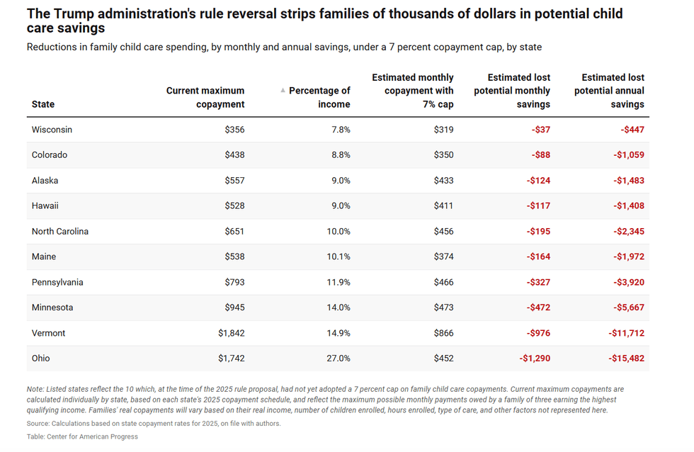 (Graphic from the Center for American Progress)
Murray (D-Wash), the former chair of the Senate Committee on Health, Education, Labor, and Pensions (HELP), introduced a resolution last month under the Congressional Review Act, which would have nullified the administration's elimination of the 7% cap.
It also would have restored other Biden-era requirements that were reversed under the same rule, including requirements that states pay childcare providers based on enrollment rather than attendance, pay them in advance, and use grants and contracts to fund childcare for infants, children with disabilities, and those in underserved communities.
In a speech on the Senate floor before the resolution came to a procedural vote on Thursday, she told her colleagues bluntly, “You are either voting to lower childcare costs or to increase them.”
She challenged the senators who planned to vote against the resolution to “go home and tell the parents in your state you voted to raise their childcare bill,” adding that “you cannot call yourself pro-family while voting to make it more expensive to raise one.”
In a party-line vote on Friday, the bill was blocked from advancing by a margin of 52-47, with every Republican voting against it except for Sen. Mitch McConnell (R-Ky.), who is absent after being hospitalized in June.
After the vote failed, Murray described it as an example of Republicans taking money away from American families struggling to afford the basics of life while pushing for lavish spending on war and tax cuts for corporations and the wealthy.
“How about instead of a $1.5 trillion war budget, we make sure every working family in America can afford childcare?” Murray said. “If Trump had simply done nothing, and left the 7% cap in place, some of these families would have ended up saving as much as $15,000 a year for their family.”
According to a Century Foundation analysis of Bureau of Labor Statistics data, childcare costs increased by 5% from August 2024 to August 2025 and now average more than $13,000 per child per year across age groups.
Trump has been surprisingly open about the fact that, under his control, and in direct contrast with his campaign promises, the federal government is prioritizing spending on his war in Iran instead of providing government subsidies for Americans’ basic needs, including daycare.
"We’re fighting wars. We can’t take care of daycare," he said during a speech in April. "You gotta let a state take care of daycare, and they should pay for it too. It’s not possible for us to take care of daycare, Medicaid, Medicare, all these individual things.”
“Trump says we can’t afford childcare. But he is wrong,” said Murray, who has co-introduced legislation to expand federal childcare subsidies and cover nearly all costs for low-income families. “The truth is we can’t afford to ignore childcare.”

"I am trying to see how this operation differs from a classic organized crime protection racket. I see little distinction."
A Thursday report in The Wall Street Journal revealed new details on President Donald Trump's attempts to shake down major corporate donors to fund his assorted vanity projects, including the construction of his luxury White House ballroom and his presidential library.
According to the Journal, Trump employs a fundraiser named Meredith O’Rourke whose job is to hound corporations into sending money to the president's projects.
O'Rourke's work is so important to the president, the Journal added, that he asks her for updates on her progress in raking in corporate cash almost nightly.
"Trump asks O’Rourke which companies and donors have cut checks and which haven’t, and for how much," the Journal reported. "He often asks her to make much larger financial requests than she was planning—for some donors the ask is $5 million, for others it is $50 million. And the president gives her names to call, often including people who have recently met with him, according to people with knowledge of the calls."
The Journal estimated that Trump has raised more than $800 million from corporate donors throughout his second term, and the newspaper found that it appeared to be entirely legal.
"No laws prohibit presidents from raising unlimited sums of money for nonprofits, like the ones used for the ballroom and his presidential library, his super PAC, or political issue committees," the Journal explained. "For most of these types of transactions, public disclosure of donors isn’t required and reporting on spending is infrequent."
Regardless of technical legality, many critics called the president's actions deeply corrupt, especially since many of the companies being shaken down for cash have business before the federal government.
" Donald Trump is the most corrupt president in our nation’s history," wrote Sen. Elizabeth Warren (D-Mass.) in reaction to the Journal's report.
Adam Serwer, staff writer at The Atlantic, joked that Trump technically "can’t be bought" because "he is subscription based."
"You have to keep bribing him forever," Serwer quipped.
Eric Rauchway, historian at the University of California, Davis, noted the Journal's reporting that O'Rourke will sometimes try to persuade corporate donors by telling them that "the boss wants this money," which he likened to a mafia extortion scheme.
"Guys, 'the boss wants this money' is not 'fundraising,'" wrote Rauchway, "it's a Piranha Brothers operation."
Scott Horton, contributing editor at Harper's, made a similar analogy.
"I am trying to see how this operation differs from a classic organized crime protection racket," Horton wrote. "I see little distinction."
Amanda Carpenter, writer and editor at Protect Democracy, argued that Trump wasn't the only party meriting criticism here, as the corporations who give in to his demands deserve blame as well.
"If a politician is selling access and favors, CEOs aren’t off the hook," she observed. "They don’t get to just pay to play. It’s not a free pass to bribe and extort and corrupt our economy. There are many legal tools to track that on the private side and hold them account for their end of these dirty deals."
"We need to massively step up our response," said one senior UN official, while another stressed that "Ebola feeds on delay, fear, and hunger."
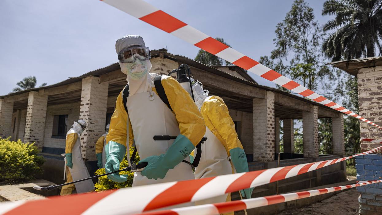
As the official death toll from the Ebola epidemic in the Democratic Republic of Congo topped 1,500, United Nations officials called for a dramatic expansion of humanitarian assistance to combat what's now the fastest-spreading outbreak of the deadly disease ever recorded.
The DRC's Health Ministry on Friday confirmed more than 3,400 infections and at least 1,556 deaths since the outbreak was declared in May. The ministry said the fatality rate during the current epidemic is 44%.
The epidemic is caused by the rare Bundibugyo strain of the Ebola virus, which has spread across multiple DRC provinces, with the vast majority of cases concentrated in Ituri Province. Unlike the Zaire strain from previous outbreaks, there is currently no approved vaccine or treatment for the Bundibugyo virus.
The current epidemic has killed more people faster than any previous outbreak, including in 2014-16, when more than 28,000 infections and over 11,000 deaths were reported.
"In the last 24 hours, 50 people have died of Ebola in the Democratic Republic of the Congo and the number of cases is growing exponentially, doubling every 20 days,” senior United Nations aiEbola coordinator Julien Harneis said during a Wednesday press conference in New York.
“So, in support of the government, I'm calling that we step up, across the response, the United Nations, nongovernmental organizations, member states,” Harneis continued. "We need to massively step up our response, be it in terms of supplies, specialized supplies like personal protective equipment, staff, specialized medical staff, and logistics as well.”
Harneis spoke at the press conference with acting UN World Food Program Executive Director Carl Skau, who said that "Ebola feeds on delay, fear, and hunger."
“Stopping this outbreak requires all hands on deck and communities at the center," he continued. "Food assistance is frontline Ebola containment. It helps families stay home, supports safe isolation, builds trust with communities, and keeps health teams moving. We know what works; what we need now is the speed and resources to scale it before this outbreak outruns the response.”
Skau noted that around 10 million people are suffering from acute food insecurity in the eastern DRC, with 3 million of those in an Integrated Food Security Phase Classification (IPC)-designated "emergency"—one step away from famine.
“You cannot force people to choose between hunger and health,” he said.
Compounding the crisis, a growing number of Ebola patients are dying outside of treatment centers. Officials said that more than 60% of recent Ebola deaths have occurred in communities, increasing the risk of further transmission through unsafe caregiving and burial practices.
Health workers also continue to endure attacks by armed groups, which have forced aid organizations to suspend operations in some of the hardest-hit areas of the epidemic.
Some experts also pointed to US President Donald Trump’s ideologically driven decision to withdraw the US from the World Health Organization, his administration’s dismantling of the US Agency for International Development, and reduced funding for the US Centers for Disease Control and Prevention’s global public health efforts as adversely affecting the response to the current Ebola epidemic, especially when compared with outbreaks in 2014 and 2019.
Meanwhile, health officials in neighboring Uganda this week declared an end to the country's Bundibugyo outbreak after no new cases were reported for a month. Twenty people were infected, and three died, in Uganda.

"This White House-Wall Street-Trump-Business feedback loop represents the depraved essence of insider trading," said the Maryland Democrat.
"Are you helping the president sell people advance access to market-moving information?"
That's the opening line of a Thursday letter that US House Judiciary Committee Ranking Member Jamie Raskin (D-Md.) sent to Kevin McGurn, interim CEO of President Donald Trump's Trump Media & Technology Group (TMTG) Corp.
TMTG runs Trump's Truth Social platform and earlier this month announced plans to launch "Truth API" by August 1. API, or application programming interface, lets software applications talk to each other. Critics have warned that the new endeavor will give Wall Street firms faster access to posts by the president and other top accounts.
"Trump Media's target market for buyers of this service is 'high-frequency and algorithmic trading firms,' which would each pay a
handsome $100,000 monthly subscription fee," Raskin wrote. "Nearly half of each fee would go directly into the pocket of Donald Trump, who owns roughly 41% of the company's shares through a trust that he continues to control."
"Put another way, Trump Media will soon be selling early access to President Trump's so-called 'Truth' missives to the most sophisticated investment firms in the world," he stressed. "This insider-information scheme will enable Wall Street to profit from the president's frequent market-moving posts on major businesses and cash in on swings in stock prices caused by the president's buying and selling (or pumping and dumping, if you prefer) of publicly traded stocks to unwitting retail investors."
As Investopedia pointed out Thursday: "In recent months Trump has posted about new developments in the Iran War, which is particularly important for buyers and sellers of futures contracts who are trying to ascertain where oil prices are headed. Over the past year, he has also posted about tariff policy, government investments in publicly traded companies, and other corporate news developments."
Additionally, as Raskin highlighted, "Trump has promoted over 20 companies on his Truth Social account shortly after purchasing the companies’ stocks, including government contractors where the Trump administration exerted substantial ability to move markets in those companies' favor. Donald Trump Jr.'s investment firm, 1789 Capital, has posted a staggering 200% investment return since his father's return to the White House, with the president recently admitting that his oldest sons are coventurers in his corruption."
Once the new service is up and running, "whenever President Trump uses Truth Social to announce that a ceasefire is imminent, or prematurely leaks US jobs data, his customers will now be able to front-run the market using their privileged access to his social media posts, leaving retail investors, pension plans, and retirement accounts irreparably disadvantaged," he warned. "This is precisely the type of harm that federal securities laws are designed to prevent."
Concerns about TMTG's plans led Democratic Sens. Elizabeth Warren (Mass.) and Adam Schiff (Calif.) to demand that US Securities and Exchange Commission Chair Paul Atkins launch an investigation. The senators wrote to the Trump-nominated SEC leader on Tuesday that the current administration "is the most corrupt in the nation's history," and the company's "new service threatens to undermine the integrity of capital markets."
In the meantime, Raskin—a constitutional scholar who managed Trump's historic second impeachment—is conducting his own probe of what he called a "reverse Robin Hood scheme," arguing that "this White House-Wall Street-Trump-Business feedback loop represents the depraved essence of insider trading." The congressman is demanding a lengthy list of records from the CEO of Trump's company by August 13.
"The president of the United States should be using the office to 'take care' that laws are enforced and to advance the public interest," he said, nodding to the US Constitution. "Instead, President Trump is, once again, using it to enrich in spectacular fashion himself, his family, and corporate cronies while also destroying the integrity of financial markets in the process."