

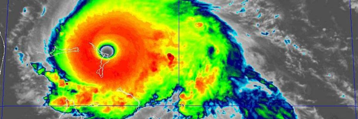
Hurricane Dorian made landfall in the Bahamas as a category 5 storm on Sunday, Sept. 1. (Image: NOAA via National Hurricane Center/Twitter)
'Historic, Catastrophic' Category 5 Hurricane Dorian Hits Bahamas, Still Threatens Southeast US Coast
As footage of the devastation began to emerge online, one expert warned that "if we continue to increase our emissions of greenhouse gasses, these kind of damages will also increase."
The "historic, catastrophic" category 5 Hurricane Dorian hit the Bahamas Sunday--eliciting a slew of urgent public safety warnings, concerns about what's in store for the Southeastern coast of the United States next week, and impassioned demands for ambitious government action to combat the global climate emergency.
Dorian made landfall at Elbow Cay, Abacos in the Bahamas early Sunday afternoon with maximum sustained winds of 185 mph and gusts over 220 mph, according to the U.S. National Hurricane Center. The eye of the hurricane made a second landfall on Great Abaco Island near Marsh Harbor later in the afternoon, with the same sustained windspeed. The center noted in an update on Twitter that "this is tied for the strongest Atlantic hurricane landfall on record with the 1935 Labor Day hurricane."
Acknowledging Dorian's significant windspeed Sunday, meteorologist and science writer Eric Holthaus tweeted, "This is a historic hurricane, and the damage in the Bahamas will be absolute."
In a series of tweets Sunday, Bill McKibben, co-founder of the environmental advocacy group 350.org, pointed out that this is the fourth consecutive year that the Atlantic has seen a category 5 hurricane and wrote that "people are going to need to rally to the relief of what must be devastated islands."
The Weather Channel, which McKibben cited, explained that "category 5 hurricanes are rare and have maximum sustained winds 157 mph or greater. They can unleash devastating winds and catastrophic storm surge when they strike land."
The National Hurricane Center continued to issue advisories about Dorian's severity for residents of the Bahamas throughout the afternoon Sunday. Warning of "storm surge 18 to 23 feet above normal tide levels with higher destructive wave," the center said in one update: "This is a life-threatening situation. Residents in the Abacos should stay in their shelter. Do not venture out into the eye if it passes over your location."
Videos of conditions in the Bahamas began circulating online Sunday afternoon--along with warnings from experts that such devastation from natural disasters will continue to worsen as long as humanity continues to fuel the global climate crisis with activities that produce planet-heating emissions:
Bahamas "Prime Minister Hubert Minnis said Saturday that 73,000 residents and 21,000 homes would be affected by the storm," The New York Times reported.
Louby Georges, director of international affairs for Human Rights Bahamas, said people on Great Abaco Island, in the direct path of the eye, were growing desperate as the storm bore down on them.
"People are sending voice notes, people are crying," he said. "You can hear people hollering in the background."
He said the shelters on the island were full and that many poorer residents had taken refuge in churches in Marsh Harbour. But he was worried that the churches, which were not on official lists of shelters to receive food and water, may run out of supplies.
"My guy at St. Francis Church said there is no drinking water," Mr. Georges said in a telephone interview from Nassau, the capital. "There are no trained emergency personnel with them."
In an advisory Sunday afternoon, the National Hurricane Center said that on its current track, "the core of extremely dangerous Hurricane Dorian will continue to pound Great Abaco today and the move near or over Grand Bahama Island tonight and Monday. The hurricane should move closer to the Florida east coast late Monday through Tuesday night."
The Associated Press detailed "Hurricane Dorian's slow dance with the coast" of Florida in a report Sunday.
The National Hurricane Center forecasts Dorian to be 40 to 50 miles off the Florida coast on Tuesday and Wednesday, with hurricane-force wind speeds extending about 35 miles to the west.
But that's just one point that forecasters have to choose to place the monstrous storm that packed 185 mph winds on Sunday. It could be within 100 miles of that point, which is why the hurricane center uses--and emphasizes--a shaded cone of uncertainty.
And much of the Florida coast is inside that cone.
As the center's director, Ken Graham, told the AP, "The cone is so important." Graham explained that with each new forecast, "we keep nudging [Dorian's track] a little bit to the left," toward the U.S. coastline.
Early Sunday evening, the Miami-based National Hurricane Center issued its first hurricane warning and watch for Florida. The warning "covers an area from Jupiter Inlet to the Volusia/Brevard County line," while the watch covers "from Voluisa/Brevard Countyline to the Flagler-Volusia county line," according to the AP.
An Urgent Message From Our Co-Founder
Dear Common Dreams reader, It’s been nearly 30 years since I co-founded Common Dreams with my late wife, Lina Newhouser. We had the radical notion that journalism should serve the public good, not corporate profits. It was clear to us from the outset what it would take to build such a project. No paid advertisements. No corporate sponsors. No millionaire publisher telling us what to think or do. Many people said we wouldn't last a year, but we proved those doubters wrong. Together with a tremendous team of journalists and dedicated staff, we built an independent media outlet free from the constraints of profits and corporate control. Our mission has always been simple: To inform. To inspire. To ignite change for the common good. Building Common Dreams was not easy. Our survival was never guaranteed. When you take on the most powerful forces—Wall Street greed, fossil fuel industry destruction, Big Tech lobbyists, and uber-rich oligarchs who have spent billions upon billions rigging the economy and democracy in their favor—the only bulwark you have is supporters who believe in your work. But here’s the urgent message from me today. It's never been this bad out there. And it's never been this hard to keep us going. At the very moment Common Dreams is most needed, the threats we face are intensifying. We need your support now more than ever. We don't accept corporate advertising and never will. We don't have a paywall because we don't think people should be blocked from critical news based on their ability to pay. Everything we do is funded by the donations of readers like you. When everyone does the little they can afford, we are strong. But if that support retreats or dries up, so do we. Will you donate now to make sure Common Dreams not only survives but thrives? —Craig Brown, Co-founder |
The "historic, catastrophic" category 5 Hurricane Dorian hit the Bahamas Sunday--eliciting a slew of urgent public safety warnings, concerns about what's in store for the Southeastern coast of the United States next week, and impassioned demands for ambitious government action to combat the global climate emergency.
Dorian made landfall at Elbow Cay, Abacos in the Bahamas early Sunday afternoon with maximum sustained winds of 185 mph and gusts over 220 mph, according to the U.S. National Hurricane Center. The eye of the hurricane made a second landfall on Great Abaco Island near Marsh Harbor later in the afternoon, with the same sustained windspeed. The center noted in an update on Twitter that "this is tied for the strongest Atlantic hurricane landfall on record with the 1935 Labor Day hurricane."
Acknowledging Dorian's significant windspeed Sunday, meteorologist and science writer Eric Holthaus tweeted, "This is a historic hurricane, and the damage in the Bahamas will be absolute."
In a series of tweets Sunday, Bill McKibben, co-founder of the environmental advocacy group 350.org, pointed out that this is the fourth consecutive year that the Atlantic has seen a category 5 hurricane and wrote that "people are going to need to rally to the relief of what must be devastated islands."
The Weather Channel, which McKibben cited, explained that "category 5 hurricanes are rare and have maximum sustained winds 157 mph or greater. They can unleash devastating winds and catastrophic storm surge when they strike land."
The National Hurricane Center continued to issue advisories about Dorian's severity for residents of the Bahamas throughout the afternoon Sunday. Warning of "storm surge 18 to 23 feet above normal tide levels with higher destructive wave," the center said in one update: "This is a life-threatening situation. Residents in the Abacos should stay in their shelter. Do not venture out into the eye if it passes over your location."
Videos of conditions in the Bahamas began circulating online Sunday afternoon--along with warnings from experts that such devastation from natural disasters will continue to worsen as long as humanity continues to fuel the global climate crisis with activities that produce planet-heating emissions:
Bahamas "Prime Minister Hubert Minnis said Saturday that 73,000 residents and 21,000 homes would be affected by the storm," The New York Times reported.
Louby Georges, director of international affairs for Human Rights Bahamas, said people on Great Abaco Island, in the direct path of the eye, were growing desperate as the storm bore down on them.
"People are sending voice notes, people are crying," he said. "You can hear people hollering in the background."
He said the shelters on the island were full and that many poorer residents had taken refuge in churches in Marsh Harbour. But he was worried that the churches, which were not on official lists of shelters to receive food and water, may run out of supplies.
"My guy at St. Francis Church said there is no drinking water," Mr. Georges said in a telephone interview from Nassau, the capital. "There are no trained emergency personnel with them."
In an advisory Sunday afternoon, the National Hurricane Center said that on its current track, "the core of extremely dangerous Hurricane Dorian will continue to pound Great Abaco today and the move near or over Grand Bahama Island tonight and Monday. The hurricane should move closer to the Florida east coast late Monday through Tuesday night."
The Associated Press detailed "Hurricane Dorian's slow dance with the coast" of Florida in a report Sunday.
The National Hurricane Center forecasts Dorian to be 40 to 50 miles off the Florida coast on Tuesday and Wednesday, with hurricane-force wind speeds extending about 35 miles to the west.
But that's just one point that forecasters have to choose to place the monstrous storm that packed 185 mph winds on Sunday. It could be within 100 miles of that point, which is why the hurricane center uses--and emphasizes--a shaded cone of uncertainty.
And much of the Florida coast is inside that cone.
As the center's director, Ken Graham, told the AP, "The cone is so important." Graham explained that with each new forecast, "we keep nudging [Dorian's track] a little bit to the left," toward the U.S. coastline.
Early Sunday evening, the Miami-based National Hurricane Center issued its first hurricane warning and watch for Florida. The warning "covers an area from Jupiter Inlet to the Volusia/Brevard County line," while the watch covers "from Voluisa/Brevard Countyline to the Flagler-Volusia county line," according to the AP.