SUBSCRIBE TO OUR FREE NEWSLETTER
Daily news & progressive opinion—funded by the people, not the corporations—delivered straight to your inbox.
5
#000000
#FFFFFF
To donate by check, phone, or other method, see our More Ways to Give page.
A new report shows that many previous estimates of global sea level rise by 2100 were far too conservative, the Washington Post reported Thursday, and the research comes as new maps and graphics from Climate Central vividly show how disastrous that flooding will be for U.S. cities.
The report, Snow, Water, Ice and Permafrost in the Arctic, found that previous estimates of sea level rise didn't account enough for the fast pace of melting ice in the Arctic and Greenland.
The Post writes:
The assessment found that under a relatively moderate global warming scenario--one that slightly exceeds the temperature targets contained in the Paris climate agreement--seas could be expected to rise "at least" 52 centimeters, or 1.7 feet, by the year 2100. Under a more extreme, "business as usual" warming scenario, meanwhile, the minimum rise would be 74 centimeters, or 2.4 feet.
The report explored a minimum rise scenario, but not a maximum or worst-case scenario. However, a separate report (pdf) published at the end of the Obama administration by the National Oceanic and Atmospheric Administration (NOAA) did just that, and found that in the most extreme case, the sea in some locations will rise a stunning eight feet by the century's end.
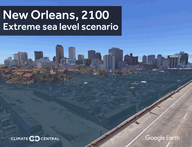
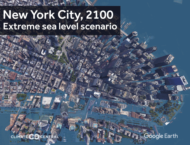
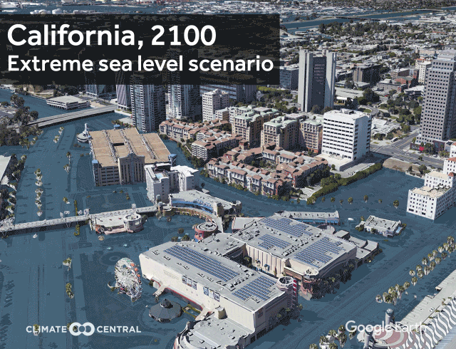
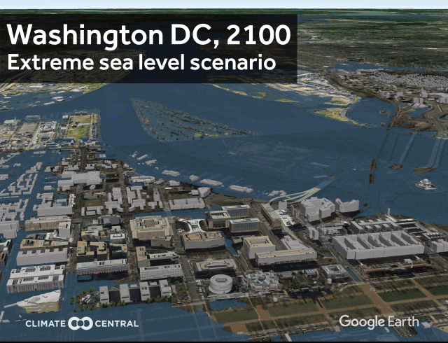
Illustrating how devastating this would be, Climate Central created 3D visualizations of what U.S. cities will look like in NOAA's most extreme scenario.
Some cities, such as New Orleans, would simply be uninhabitable, the images show:
Rising seas alone may displace over 13 million people in the U.S., dispersing climate refugees and reshaping inland cities, as Common Dreams reported last week.
See more examples of Climate Central's visualizations here and here, and find a 2D map of sea level rise projections here.
The ominous new research come as President Donald Trump continues to dismantle climate policies, boosts the fossil fuel industry, and considers pulling out of the Paris climate accord.
But even Trump won't be spared from the looming disaster, Climate Central observes, showing that the projected sea level rise will completely flood the president's Mar-a-Lago resort.
A new report shows that many previous estimates of global sea level rise by 2100 were far too conservative, the Washington Post reported Thursday, and the research comes as new maps and graphics from Climate Central vividly show how disastrous that flooding will be for U.S. cities.
The report, Snow, Water, Ice and Permafrost in the Arctic, found that previous estimates of sea level rise didn't account enough for the fast pace of melting ice in the Arctic and Greenland.
The Post writes:
The assessment found that under a relatively moderate global warming scenario--one that slightly exceeds the temperature targets contained in the Paris climate agreement--seas could be expected to rise "at least" 52 centimeters, or 1.7 feet, by the year 2100. Under a more extreme, "business as usual" warming scenario, meanwhile, the minimum rise would be 74 centimeters, or 2.4 feet.
The report explored a minimum rise scenario, but not a maximum or worst-case scenario. However, a separate report (pdf) published at the end of the Obama administration by the National Oceanic and Atmospheric Administration (NOAA) did just that, and found that in the most extreme case, the sea in some locations will rise a stunning eight feet by the century's end.
Illustrating how devastating this would be, Climate Central created 3D visualizations of what U.S. cities will look like in NOAA's most extreme scenario.
Some cities, such as New Orleans, would simply be uninhabitable, the images show:
Rising seas alone may displace over 13 million people in the U.S., dispersing climate refugees and reshaping inland cities, as Common Dreams reported last week.
See more examples of Climate Central's visualizations here and here, and find a 2D map of sea level rise projections here.
The ominous new research come as President Donald Trump continues to dismantle climate policies, boosts the fossil fuel industry, and considers pulling out of the Paris climate accord.
But even Trump won't be spared from the looming disaster, Climate Central observes, showing that the projected sea level rise will completely flood the president's Mar-a-Lago resort.