
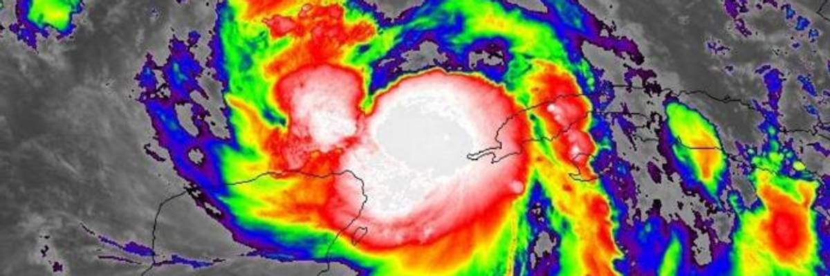
Meteorologists have been documenting Hurricane Nate's growing strength on social media, warning that the storm is picking up speed at a "terrifying" rate and that its impact could seriously stress levees. (Photo: Capital Weather Gang/Twitter)
Warnings of 'Life-Threatening Flooding' as Hurricane Nate Barrels Toward Gulf Coast
"Nate is the ninth hurricane of the 2017 Atlantic season, and the ninth storm in a row in the basin to reach hurricane strength."
Having already "left a path of devastation through Central America," Hurricane Nate--which was upgraded from a tropical storm late Friday--is now barreling toward the northern Gulf Coast of the U.S., and states have begun urgently bracing for impact. The storm is expected to make landfall between New Orleans and Mobile, Alabama late Saturday or early Sunday.
As CNN reports, Nate--the latest storm amid a devastating and unprecedented hurricane season--is already responsible for at least 24 deaths in Costa Rica, Nicaragua, and Honduras, and hundreds had to be rescued from mudslides and intense flooding.
With the storm rapidly hurtling toward the coastal United States after picking up speed in the "unusually warm waters" of the Gulf of Mexico, Louisiana, Mississippi, Alabama, and Florida have all declared states of emergency and ordered evacuations of low-lying areas.
While Nate has been classified as a Category 1 hurricane, registering over 80 mph winds, the Washington Post notes that the storm could ultimately grow to a Category 2, with winds reaching over 95 mph.
The Post went on to detail preparations currently underway in New Orleans, where residents have been warned to expect power outages:
By Saturday, the Port of New Orleans will be closed, and most of the 200 floodgates in the city and surrounding parishes will be closed. More than 350 members of the National Guard will be on the ground.
Friday morning, the city began providing 17,000 sandbags to residents at five locations across town. Police set up 146 barricades in flood-prone areas, and boats and high-water vehicles were lined up at fire and police stations.
Melonie Stewart, customer service director at Entergy, New Orleans's sole energy provider, warned residents to be prepared for up to seven days without power from the grid.
The National Hurricane Center has warned that "life-threatening storm surge flooding is likely along portions of the northern Gulf Coast," adding: "Residents in these areas should heed any evacuation instructions given by local officials."
Meteorologists have been documenting Hurricane Nate's growing strength on social media, warning that the storm is picking up speed at a "terrifying" rate and that its impact could seriously stress levees.
An Urgent Message From Our Co-Founder
Dear Common Dreams reader, It’s been nearly 30 years since I co-founded Common Dreams with my late wife, Lina Newhouser. We had the radical notion that journalism should serve the public good, not corporate profits. It was clear to us from the outset what it would take to build such a project. No paid advertisements. No corporate sponsors. No millionaire publisher telling us what to think or do. Many people said we wouldn't last a year, but we proved those doubters wrong. Together with a tremendous team of journalists and dedicated staff, we built an independent media outlet free from the constraints of profits and corporate control. Our mission has always been simple: To inform. To inspire. To ignite change for the common good. Building Common Dreams was not easy. Our survival was never guaranteed. When you take on the most powerful forces—Wall Street greed, fossil fuel industry destruction, Big Tech lobbyists, and uber-rich oligarchs who have spent billions upon billions rigging the economy and democracy in their favor—the only bulwark you have is supporters who believe in your work. But here’s the urgent message from me today. It's never been this bad out there. And it's never been this hard to keep us going. At the very moment Common Dreams is most needed, the threats we face are intensifying. We need your support now more than ever. We don't accept corporate advertising and never will. We don't have a paywall because we don't think people should be blocked from critical news based on their ability to pay. Everything we do is funded by the donations of readers like you. When everyone does the little they can afford, we are strong. But if that support retreats or dries up, so do we. Will you donate now to make sure Common Dreams not only survives but thrives? —Craig Brown, Co-founder |
Having already "left a path of devastation through Central America," Hurricane Nate--which was upgraded from a tropical storm late Friday--is now barreling toward the northern Gulf Coast of the U.S., and states have begun urgently bracing for impact. The storm is expected to make landfall between New Orleans and Mobile, Alabama late Saturday or early Sunday.
As CNN reports, Nate--the latest storm amid a devastating and unprecedented hurricane season--is already responsible for at least 24 deaths in Costa Rica, Nicaragua, and Honduras, and hundreds had to be rescued from mudslides and intense flooding.
With the storm rapidly hurtling toward the coastal United States after picking up speed in the "unusually warm waters" of the Gulf of Mexico, Louisiana, Mississippi, Alabama, and Florida have all declared states of emergency and ordered evacuations of low-lying areas.
While Nate has been classified as a Category 1 hurricane, registering over 80 mph winds, the Washington Post notes that the storm could ultimately grow to a Category 2, with winds reaching over 95 mph.
The Post went on to detail preparations currently underway in New Orleans, where residents have been warned to expect power outages:
By Saturday, the Port of New Orleans will be closed, and most of the 200 floodgates in the city and surrounding parishes will be closed. More than 350 members of the National Guard will be on the ground.
Friday morning, the city began providing 17,000 sandbags to residents at five locations across town. Police set up 146 barricades in flood-prone areas, and boats and high-water vehicles were lined up at fire and police stations.
Melonie Stewart, customer service director at Entergy, New Orleans's sole energy provider, warned residents to be prepared for up to seven days without power from the grid.
The National Hurricane Center has warned that "life-threatening storm surge flooding is likely along portions of the northern Gulf Coast," adding: "Residents in these areas should heed any evacuation instructions given by local officials."
Meteorologists have been documenting Hurricane Nate's growing strength on social media, warning that the storm is picking up speed at a "terrifying" rate and that its impact could seriously stress levees.