SUBSCRIBE TO OUR FREE NEWSLETTER
Daily news & progressive opinion—funded by the people, not the corporations—delivered straight to your inbox.
5
#000000
#FFFFFF
To donate by check, phone, or other method, see our More Ways to Give page.
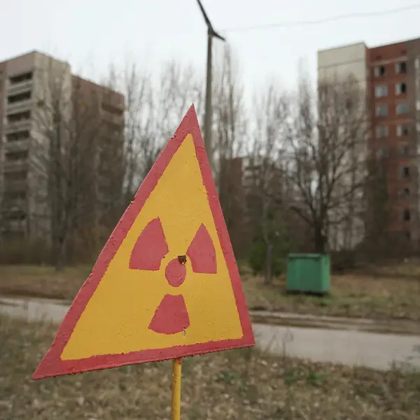
Japan is bracing for Typhoon Wipha's landfall on Wednesday, a storm that could be the strongest in a decade to hit Tokyo, and one that has the potential to bring flooding to the Fukushima nuclear power plant.
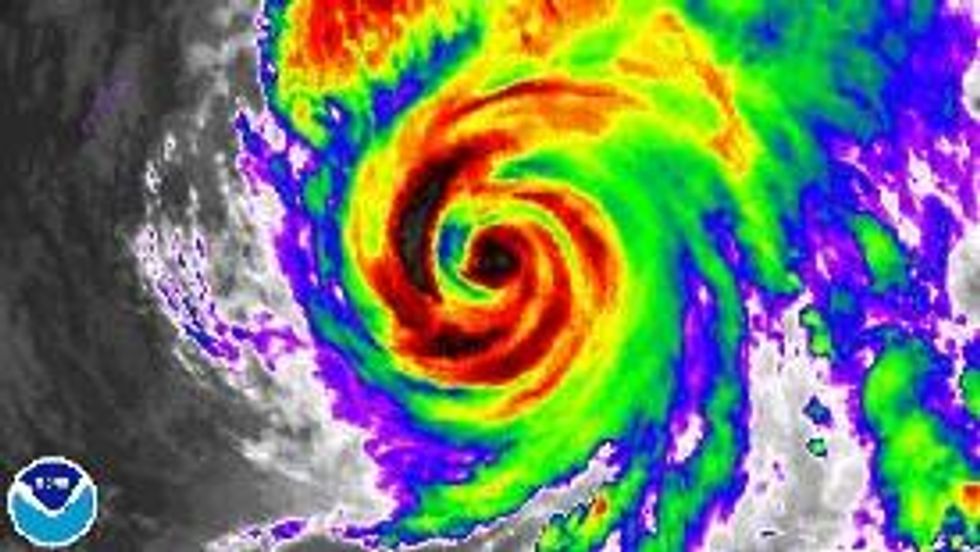
Heavy rains and damaging winds that could lead to power outages are expected along the country's east coast. The storm was weakening across the Pacific, but was still bringing winds gusts of up to 120 mph.
The center of the storm could be close to Tokyo, and "If its center passes just west of Tokyo, a large storm surge would affect the city of more than 35 million people and potentially bring major flooding," the Washington Post reports.
Reuters reports that Wipha "is expected to sweep through northern Japan after making landfall and to pass near the crippled Fukushima nuclear power plant, on the coast 220 km (130 miles) northeast of Tokyo, later on Wednesday."
Meteorologist Jeff Masters of Weather Underground warns that
Heavy rains from Wipha may be a concern for the Fukushima nuclear site, where rainfall from Typhoon Man-Yi on September 16 complicated clean-up efforts of the reactors damaged by the March 2011 earthquake and tsunami.
The heavy rainwater risk to Fukushima is echoed by meteorologist Eric Holthaus, who writes:
Some weather models predict heavy rains in excess of five inches (125 mm) to fall over the next 12 hours--a true deluge. However, unlike during Man-yi in September, the closer approach of the more intense Wipha could lead to strong winds, as well. The JMA gave a greater than 90% chance of winds in excess of 55 mph (90 kph) in Tokyo and along the coast of Fukushima for the next 12 hours.
Workers at the Fukushima plant have taken extra measures in preparation for the coming typhoon, according to plant operator TEPCO, getting new storage tanks ready for rising water levels and to prevent leakage of stored radioactive water.
* * *
___________________
Japan is bracing for Typhoon Wipha's landfall on Wednesday, a storm that could be the strongest in a decade to hit Tokyo, and one that has the potential to bring flooding to the Fukushima nuclear power plant.
Heavy rains and damaging winds that could lead to power outages are expected along the country's east coast. The storm was weakening across the Pacific, but was still bringing winds gusts of up to 120 mph.
The center of the storm could be close to Tokyo, and "If its center passes just west of Tokyo, a large storm surge would affect the city of more than 35 million people and potentially bring major flooding," the Washington Post reports.
Reuters reports that Wipha "is expected to sweep through northern Japan after making landfall and to pass near the crippled Fukushima nuclear power plant, on the coast 220 km (130 miles) northeast of Tokyo, later on Wednesday."
Meteorologist Jeff Masters of Weather Underground warns that
Heavy rains from Wipha may be a concern for the Fukushima nuclear site, where rainfall from Typhoon Man-Yi on September 16 complicated clean-up efforts of the reactors damaged by the March 2011 earthquake and tsunami.
The heavy rainwater risk to Fukushima is echoed by meteorologist Eric Holthaus, who writes:
Some weather models predict heavy rains in excess of five inches (125 mm) to fall over the next 12 hours--a true deluge. However, unlike during Man-yi in September, the closer approach of the more intense Wipha could lead to strong winds, as well. The JMA gave a greater than 90% chance of winds in excess of 55 mph (90 kph) in Tokyo and along the coast of Fukushima for the next 12 hours.
Workers at the Fukushima plant have taken extra measures in preparation for the coming typhoon, according to plant operator TEPCO, getting new storage tanks ready for rising water levels and to prevent leakage of stored radioactive water.
* * *
___________________