SUBSCRIBE TO OUR FREE NEWSLETTER
Daily news & progressive opinion—funded by the people, not the corporations—delivered straight to your inbox.
5
#000000
#FFFFFF
To donate by check, phone, or other method, see our More Ways to Give page.
Daily news & progressive opinion—funded by the people, not the corporations—delivered straight to your inbox.
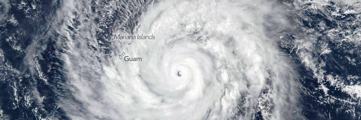
Super Typhoon Sinlaku makes landfall the North Pacific Ocean, as seen in a satellite photo captured on April 13, 2026.
The latest storm continues a trend of "unprecedented battering" by Category 4s and 5s for US territories.
Super Typhoon Sinlaku slammed into the Northern Mariana Islands on Tuesday, causing severe damage to the US-controlled territories that are home to roughly 50,000 people.
According to a Tuesday report from The Associated Press, the typhoon that struck the islands of Tinian and Saipan was the strongest storm recorded so far this year, delivering sustained winds of up to 150 miles per hour.
Saipan Mayor Ramon "RB" Jose Blas Camacho told the AP he was concerned about how the storm's severity was hindering local rescue operations.
"It’s so difficult for us to respond with this heavy rain, heavy wind to rescue people," he said. "Objects are just flying left and right.”
Marko Korosec, a storm chaser and weather forecaster, analyzed satellite images of the storm and predicted the Northern Mariana Islands would be hit with "violent, destructive winds, catastrophic storm surges, giant waves, and flooding rain."
"The damage," he wrote, "will be extreme."
An analysis of the storm written by hurricane scientist Jeff Masters and published by Yale Climate Connections projected that "damage from Sinlaku will be severe on both islands."
Masters also said Sinlaku was just the latest in what he described as an "unprecedented" number of Category 4 and Category 5 typhoons over the last decade, which he attributed to "a combination of natural variability and climate change."
"Beginning in 2017, the US has gotten absolutely hammered by high-intensity Category 4 and 5 hurricanes," Masters explained. "Seven have hit the continental US, one has hit Puerto Rico, and now two have hit the Northern Mariana Islands. That's as many US Cat 4 and Cat 5 landfalls as had occurred in the prior 57 years."
Later in his analysis, Masters pointed out that 10 of the 13 strongest tropical typhoons to make landfall in the last 80 years have occurred since 2006.
A Washington Post analysis of the typhoon published Tuesday noted that it's "unusually early" for a superstorm of this caliber to form in the Pacific, warning it "may be a sign of what's to come" this season.
"The season is expected to be anomalously active because of a burgeoning El Niño, which induces a warming of water temperatures," explained the Post. "That helps air to rise, generating more, and stronger, storms."
The Post added that Sinlaku is "the last in rare set of triplet cyclones that formed this month," which it said is an "unusual pattern" that is "also contributing to a burst of winds that is expected to greatly boost the odds of a super El Niño later this year, pushing warm water west-to-east across the Pacific."
Dear Common Dreams reader, It’s been nearly 30 years since I co-founded Common Dreams with my late wife, Lina Newhouser. We had the radical notion that journalism should serve the public good, not corporate profits. It was clear to us from the outset what it would take to build such a project. No paid advertisements. No corporate sponsors. No millionaire publisher telling us what to think or do. Many people said we wouldn't last a year, but we proved those doubters wrong. Together with a tremendous team of journalists and dedicated staff, we built an independent media outlet free from the constraints of profits and corporate control. Our mission has always been simple: To inform. To inspire. To ignite change for the common good. Building Common Dreams was not easy. Our survival was never guaranteed. When you take on the most powerful forces—Wall Street greed, fossil fuel industry destruction, Big Tech lobbyists, and uber-rich oligarchs who have spent billions upon billions rigging the economy and democracy in their favor—the only bulwark you have is supporters who believe in your work. But here’s the urgent message from me today. It's never been this bad out there. And it's never been this hard to keep us going. At the very moment Common Dreams is most needed, the threats we face are intensifying. We need your support now more than ever. We don't accept corporate advertising and never will. We don't have a paywall because we don't think people should be blocked from critical news based on their ability to pay. Everything we do is funded by the donations of readers like you. When everyone does the little they can afford, we are strong. But if that support retreats or dries up, so do we. Will you donate now to make sure Common Dreams not only survives but thrives? —Craig Brown, Co-founder |
Super Typhoon Sinlaku slammed into the Northern Mariana Islands on Tuesday, causing severe damage to the US-controlled territories that are home to roughly 50,000 people.
According to a Tuesday report from The Associated Press, the typhoon that struck the islands of Tinian and Saipan was the strongest storm recorded so far this year, delivering sustained winds of up to 150 miles per hour.
Saipan Mayor Ramon "RB" Jose Blas Camacho told the AP he was concerned about how the storm's severity was hindering local rescue operations.
"It’s so difficult for us to respond with this heavy rain, heavy wind to rescue people," he said. "Objects are just flying left and right.”
Marko Korosec, a storm chaser and weather forecaster, analyzed satellite images of the storm and predicted the Northern Mariana Islands would be hit with "violent, destructive winds, catastrophic storm surges, giant waves, and flooding rain."
"The damage," he wrote, "will be extreme."
An analysis of the storm written by hurricane scientist Jeff Masters and published by Yale Climate Connections projected that "damage from Sinlaku will be severe on both islands."
Masters also said Sinlaku was just the latest in what he described as an "unprecedented" number of Category 4 and Category 5 typhoons over the last decade, which he attributed to "a combination of natural variability and climate change."
"Beginning in 2017, the US has gotten absolutely hammered by high-intensity Category 4 and 5 hurricanes," Masters explained. "Seven have hit the continental US, one has hit Puerto Rico, and now two have hit the Northern Mariana Islands. That's as many US Cat 4 and Cat 5 landfalls as had occurred in the prior 57 years."
Later in his analysis, Masters pointed out that 10 of the 13 strongest tropical typhoons to make landfall in the last 80 years have occurred since 2006.
A Washington Post analysis of the typhoon published Tuesday noted that it's "unusually early" for a superstorm of this caliber to form in the Pacific, warning it "may be a sign of what's to come" this season.
"The season is expected to be anomalously active because of a burgeoning El Niño, which induces a warming of water temperatures," explained the Post. "That helps air to rise, generating more, and stronger, storms."
The Post added that Sinlaku is "the last in rare set of triplet cyclones that formed this month," which it said is an "unusual pattern" that is "also contributing to a burst of winds that is expected to greatly boost the odds of a super El Niño later this year, pushing warm water west-to-east across the Pacific."