SUBSCRIBE TO OUR FREE NEWSLETTER
Daily news & progressive opinion—funded by the people, not the corporations—delivered straight to your inbox.
5
#000000
#FFFFFF
To donate by check, phone, or other method, see our More Ways to Give page.
Daily news & progressive opinion—funded by the people, not the corporations—delivered straight to your inbox.
The Nebraska National Guard prepares to carry out an air rescue near Arlington. (Photo: @NEStatePatrol)
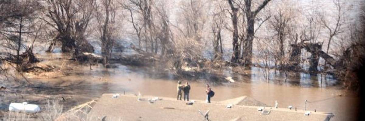
Nebraska residents are bracing for more record-breaking river levels as major flooding continues to affect portions of the Midwest.
The still-unfolding catastrophe caused at least three known deaths across the region.
The Nebraska Emergency Management Agency (NEMA) said Sunday that 17 locations across the state had been hit by record flooding, and more records could be broken over the next two days. Flooding in some areas may continue until next weekend, the agency added.
"Major to historic river flooding is expected to continue across parts of the Missouri and Mississippi River Basins," the National Weather Service warned Monday, "due to rapid snow melt the past few days."
Suggesting the still-unfolding catastrophe is a sign of a "hot new world," climate activist and author Bill McKibben tweeted, "The Midwest flooding is off the charts--at places in Nebraska, the Missouri is four feet higher than it's ever been before."
Copernicus, the European Union's Earth Observation Program, captured images of the flooding in the Cornhusker State, and said its magnitude was "biblical":
"This really is the most devastating flooding we've probably ever had in our state's history, from the standpoint of how widespread it is," Nebraska Gov. Pete Ricketts said Monday.
While Nebraska may be the most intensely affected at the moment, it is far from the only state hit by flooding. Iowa and Wisconsin also declared states of emergency as a result of of major flooding, and the graphics below show others in the Missouri and Mississippi River Basins that are facing rising waters:
The Weather Channel attributed the flooding to "a perfect storm of meteorological factors" including a "bomb cyclone" storm that brought snow and rain.
Meteorologist Jeff Masters broke down the details last week:
The heavy rains from the bomb cyclone were accompanied by very warm temperatures which melted a snowpack of 5-13" of snow. The snowpack had a high liquid water content--equivalent to an extra 1-3" of rain falling--since the snow had been accumulating and compacting since early February. When Wednesday's warm temperatures in the 50s and 60s and heavy rain melted the snow, the runoff flowed very quickly into the rivers, because the frozen ground was unable to absorb much water to slow things down. Many of the flooding rivers had thick ice covering them, due to the long stretch of cold weather the Midwest endured this winter. When the huge pulse of floodwaters entered the rivers, this caused the ice to break up and create ice jams, which blocked the flow of the rivers, causing additional flooding.
"Throughout Nebraska and the Midwest, our friends are dealing with the worst flooding in half a century," Sen. Bernie Sanders (I-Vt.) said in tweet over the weekend. "We must provide immediate help to those suffering. Long-term, we must take bold steps to stop climate change, which makes extreme flooding much worse."
Dear Common Dreams reader, It’s been nearly 30 years since I co-founded Common Dreams with my late wife, Lina Newhouser. We had the radical notion that journalism should serve the public good, not corporate profits. It was clear to us from the outset what it would take to build such a project. No paid advertisements. No corporate sponsors. No millionaire publisher telling us what to think or do. Many people said we wouldn't last a year, but we proved those doubters wrong. Together with a tremendous team of journalists and dedicated staff, we built an independent media outlet free from the constraints of profits and corporate control. Our mission has always been simple: To inform. To inspire. To ignite change for the common good. Building Common Dreams was not easy. Our survival was never guaranteed. When you take on the most powerful forces—Wall Street greed, fossil fuel industry destruction, Big Tech lobbyists, and uber-rich oligarchs who have spent billions upon billions rigging the economy and democracy in their favor—the only bulwark you have is supporters who believe in your work. But here’s the urgent message from me today. It's never been this bad out there. And it's never been this hard to keep us going. At the very moment Common Dreams is most needed, the threats we face are intensifying. We need your support now more than ever. We don't accept corporate advertising and never will. We don't have a paywall because we don't think people should be blocked from critical news based on their ability to pay. Everything we do is funded by the donations of readers like you. When everyone does the little they can afford, we are strong. But if that support retreats or dries up, so do we. Will you donate now to make sure Common Dreams not only survives but thrives? —Craig Brown, Co-founder |
Nebraska residents are bracing for more record-breaking river levels as major flooding continues to affect portions of the Midwest.
The still-unfolding catastrophe caused at least three known deaths across the region.
The Nebraska Emergency Management Agency (NEMA) said Sunday that 17 locations across the state had been hit by record flooding, and more records could be broken over the next two days. Flooding in some areas may continue until next weekend, the agency added.
"Major to historic river flooding is expected to continue across parts of the Missouri and Mississippi River Basins," the National Weather Service warned Monday, "due to rapid snow melt the past few days."
Suggesting the still-unfolding catastrophe is a sign of a "hot new world," climate activist and author Bill McKibben tweeted, "The Midwest flooding is off the charts--at places in Nebraska, the Missouri is four feet higher than it's ever been before."
Copernicus, the European Union's Earth Observation Program, captured images of the flooding in the Cornhusker State, and said its magnitude was "biblical":
"This really is the most devastating flooding we've probably ever had in our state's history, from the standpoint of how widespread it is," Nebraska Gov. Pete Ricketts said Monday.
While Nebraska may be the most intensely affected at the moment, it is far from the only state hit by flooding. Iowa and Wisconsin also declared states of emergency as a result of of major flooding, and the graphics below show others in the Missouri and Mississippi River Basins that are facing rising waters:
The Weather Channel attributed the flooding to "a perfect storm of meteorological factors" including a "bomb cyclone" storm that brought snow and rain.
Meteorologist Jeff Masters broke down the details last week:
The heavy rains from the bomb cyclone were accompanied by very warm temperatures which melted a snowpack of 5-13" of snow. The snowpack had a high liquid water content--equivalent to an extra 1-3" of rain falling--since the snow had been accumulating and compacting since early February. When Wednesday's warm temperatures in the 50s and 60s and heavy rain melted the snow, the runoff flowed very quickly into the rivers, because the frozen ground was unable to absorb much water to slow things down. Many of the flooding rivers had thick ice covering them, due to the long stretch of cold weather the Midwest endured this winter. When the huge pulse of floodwaters entered the rivers, this caused the ice to break up and create ice jams, which blocked the flow of the rivers, causing additional flooding.
"Throughout Nebraska and the Midwest, our friends are dealing with the worst flooding in half a century," Sen. Bernie Sanders (I-Vt.) said in tweet over the weekend. "We must provide immediate help to those suffering. Long-term, we must take bold steps to stop climate change, which makes extreme flooding much worse."