SUBSCRIBE TO OUR FREE NEWSLETTER
Daily news & progressive opinion—funded by the people, not the corporations—delivered straight to your inbox.
5
#000000
#FFFFFF
To donate by check, phone, or other method, see our More Ways to Give page.
Daily news & progressive opinion—funded by the people, not the corporations—delivered straight to your inbox.
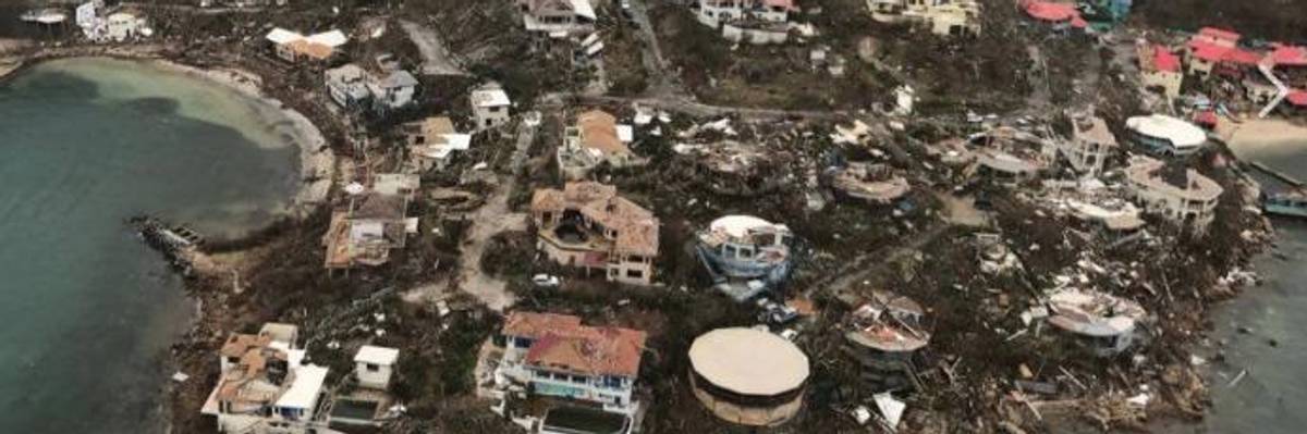
Severely damaged homes overlooking Leverick Bay on Virgin Gorda, British Virgin Islands. Photographs and video taken by Caribbean Buzz Helicopters, based in the Virgin Islands, show the scale of the devastation left by Hurricane Irma. (Photo: Caribbean Buzz Helicopters/Facebook)
As Hurricane Irma continues on its "frightening" course towards the Keys and mainland Florida, a series of aerial videos taken from the Virgin Islands in the Caribbean are offering some of the first detailed looks at what the storm's wrath is capable of and the scale of the damage suffered from those exposed to her historic size and strength.
Providing by a tourism outfit called Caribbean Buzz Helicopters, based in the Virgin Islands, and posted to their Facebook page on Friday, the videos--as well as these photographs--offered some of the first overhead surveys of St. Thomas in the U.S. Virgin Islands (USVI), the islands of Eustatia and Tortala in the British Virginia Islands (BVI), including closeup looks at specific coastal communities and smaller islands hit by the storm throughout archipelago.
Bitter End, Virgin Gorda, BVI:
St. Thomas, USVI:
Tortola, BVI:
Eustatia, BVI:
Saba Rock, BVI:
Beef Island, BVI:
Cow Wreck, Anegada, BVI:
Mafolie, St. Thomas, USVI:
Dear Common Dreams reader, It’s been nearly 30 years since I co-founded Common Dreams with my late wife, Lina Newhouser. We had the radical notion that journalism should serve the public good, not corporate profits. It was clear to us from the outset what it would take to build such a project. No paid advertisements. No corporate sponsors. No millionaire publisher telling us what to think or do. Many people said we wouldn't last a year, but we proved those doubters wrong. Together with a tremendous team of journalists and dedicated staff, we built an independent media outlet free from the constraints of profits and corporate control. Our mission has always been simple: To inform. To inspire. To ignite change for the common good. Building Common Dreams was not easy. Our survival was never guaranteed. When you take on the most powerful forces—Wall Street greed, fossil fuel industry destruction, Big Tech lobbyists, and uber-rich oligarchs who have spent billions upon billions rigging the economy and democracy in their favor—the only bulwark you have is supporters who believe in your work. But here’s the urgent message from me today. It's never been this bad out there. And it's never been this hard to keep us going. At the very moment Common Dreams is most needed, the threats we face are intensifying. We need your support now more than ever. We don't accept corporate advertising and never will. We don't have a paywall because we don't think people should be blocked from critical news based on their ability to pay. Everything we do is funded by the donations of readers like you. When everyone does the little they can afford, we are strong. But if that support retreats or dries up, so do we. Will you donate now to make sure Common Dreams not only survives but thrives? —Craig Brown, Co-founder |
As Hurricane Irma continues on its "frightening" course towards the Keys and mainland Florida, a series of aerial videos taken from the Virgin Islands in the Caribbean are offering some of the first detailed looks at what the storm's wrath is capable of and the scale of the damage suffered from those exposed to her historic size and strength.
Providing by a tourism outfit called Caribbean Buzz Helicopters, based in the Virgin Islands, and posted to their Facebook page on Friday, the videos--as well as these photographs--offered some of the first overhead surveys of St. Thomas in the U.S. Virgin Islands (USVI), the islands of Eustatia and Tortala in the British Virginia Islands (BVI), including closeup looks at specific coastal communities and smaller islands hit by the storm throughout archipelago.
Bitter End, Virgin Gorda, BVI:
St. Thomas, USVI:
Tortola, BVI:
Eustatia, BVI:
Saba Rock, BVI:
Beef Island, BVI:
Cow Wreck, Anegada, BVI:
Mafolie, St. Thomas, USVI: