SUBSCRIBE TO OUR FREE NEWSLETTER
Daily news & progressive opinion—funded by the people, not the corporations—delivered straight to your inbox.
5
#000000
#FFFFFF
To donate by check, phone, or other method, see our More Ways to Give page.
Daily news & progressive opinion—funded by the people, not the corporations—delivered straight to your inbox.
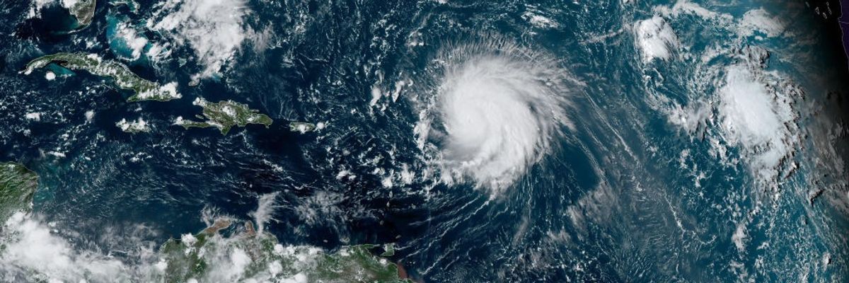
In this NOAA image taken by the GOES satellite, Hurricane Lee crosses the Atlantic Ocean as it moves west on September 8, 2023. Lee reached Category 5, but then weakened. It is still expected to be a dangerous storm as it moves over up the Atlantic, creating monster waves and possibly dangerous rip currents.
"This is your hurricane on fossil fueled climate change."
Hurricane Lee, which became a monster Category 5 before weakening over the weekend and which may or may not ever make landfall, is being treated as a warning by meteorologists and climate experts who say the storm's behavior over recent days could have dire future implications.
The National Hurricane Center said Saturday that Lee would move well north of Puerto Rico and the Virgin Islands but that dangerous beach conditions may be seen along the Atlantic coastline of the United States. On Thursday, the hurricane jumped from a Category 3 storm to a Category 5 in less than 24 hours at a pace faster than what is called "rapid intensification"—when sustained winds increase by 35 mph over the course of a day.
Marshall Shepherd, director of the University of Georgia's atmospheric sciences program and a past president of the American Meteorological Society, explained to the Associated Press how Hurricane Lee intensified at more than double that rate, moving it into a category he called hyperintensification.
"This one increased by 80 mph (129 kph)," Shepherd said. "I can't emphasize this enough. We used to have this metric of 35 mph, and here's a storm that did twice that amount, and we're seeing that happen more frequently." If future storms, fueled by increasingly hotter ocean temperatures, continue with this trend it will have disastrous consequences for regions that rarely, if ever, experience such powerful storms.
As Lee became reached Category 5 status on Thursday, meteorologist Jeff Berardelli pointed out the increasing frequency of storms reaching that threshold:
Responding to the same trend and data, climate movement organizer Jamie Henn said: "This is your hurricane on fossil fueled climate change."
And it's a global phenomenon, not just for hurricanes forming in the Atlantic. For the first time since records began, Category 5 storms (or the equivalent) have been recorded in each of the world's designated cyclone basins.
"Hurricanes are getting stronger at higher latitudes," warned Shepherd in his assessment. "If that trend continues, that brings into play places like Washington, D.C., New York and Boston."
As science and environment journalist Matt Simon wrote for Wired on Saturday:
Rapid intensification makes hurricanes extra dangerous because they change so quickly and dramatically as they approach the coastline. It's a bit like watching a driver who’s cruising along at 25 miles per hour and then guns it right before hitting an obstruction. Residents might be expecting a storm they can ride out, but are instead faced with a full-scale hurricane that's quickly grown monstrous.
Exploring the science and talking with experts of rapid intensification, Simon explained why Lee is being treated as "a warning" and that people and communities should "get ready for more of this phenomenon as the planet warms."
Dear Common Dreams reader, It’s been nearly 30 years since I co-founded Common Dreams with my late wife, Lina Newhouser. We had the radical notion that journalism should serve the public good, not corporate profits. It was clear to us from the outset what it would take to build such a project. No paid advertisements. No corporate sponsors. No millionaire publisher telling us what to think or do. Many people said we wouldn't last a year, but we proved those doubters wrong. Together with a tremendous team of journalists and dedicated staff, we built an independent media outlet free from the constraints of profits and corporate control. Our mission has always been simple: To inform. To inspire. To ignite change for the common good. Building Common Dreams was not easy. Our survival was never guaranteed. When you take on the most powerful forces—Wall Street greed, fossil fuel industry destruction, Big Tech lobbyists, and uber-rich oligarchs who have spent billions upon billions rigging the economy and democracy in their favor—the only bulwark you have is supporters who believe in your work. But here’s the urgent message from me today. It's never been this bad out there. And it's never been this hard to keep us going. At the very moment Common Dreams is most needed, the threats we face are intensifying. We need your support now more than ever. We don't accept corporate advertising and never will. We don't have a paywall because we don't think people should be blocked from critical news based on their ability to pay. Everything we do is funded by the donations of readers like you. When everyone does the little they can afford, we are strong. But if that support retreats or dries up, so do we. Will you donate now to make sure Common Dreams not only survives but thrives? —Craig Brown, Co-founder |
Hurricane Lee, which became a monster Category 5 before weakening over the weekend and which may or may not ever make landfall, is being treated as a warning by meteorologists and climate experts who say the storm's behavior over recent days could have dire future implications.
The National Hurricane Center said Saturday that Lee would move well north of Puerto Rico and the Virgin Islands but that dangerous beach conditions may be seen along the Atlantic coastline of the United States. On Thursday, the hurricane jumped from a Category 3 storm to a Category 5 in less than 24 hours at a pace faster than what is called "rapid intensification"—when sustained winds increase by 35 mph over the course of a day.
Marshall Shepherd, director of the University of Georgia's atmospheric sciences program and a past president of the American Meteorological Society, explained to the Associated Press how Hurricane Lee intensified at more than double that rate, moving it into a category he called hyperintensification.
"This one increased by 80 mph (129 kph)," Shepherd said. "I can't emphasize this enough. We used to have this metric of 35 mph, and here's a storm that did twice that amount, and we're seeing that happen more frequently." If future storms, fueled by increasingly hotter ocean temperatures, continue with this trend it will have disastrous consequences for regions that rarely, if ever, experience such powerful storms.
As Lee became reached Category 5 status on Thursday, meteorologist Jeff Berardelli pointed out the increasing frequency of storms reaching that threshold:
Responding to the same trend and data, climate movement organizer Jamie Henn said: "This is your hurricane on fossil fueled climate change."
And it's a global phenomenon, not just for hurricanes forming in the Atlantic. For the first time since records began, Category 5 storms (or the equivalent) have been recorded in each of the world's designated cyclone basins.
"Hurricanes are getting stronger at higher latitudes," warned Shepherd in his assessment. "If that trend continues, that brings into play places like Washington, D.C., New York and Boston."
As science and environment journalist Matt Simon wrote for Wired on Saturday:
Rapid intensification makes hurricanes extra dangerous because they change so quickly and dramatically as they approach the coastline. It's a bit like watching a driver who’s cruising along at 25 miles per hour and then guns it right before hitting an obstruction. Residents might be expecting a storm they can ride out, but are instead faced with a full-scale hurricane that's quickly grown monstrous.
Exploring the science and talking with experts of rapid intensification, Simon explained why Lee is being treated as "a warning" and that people and communities should "get ready for more of this phenomenon as the planet warms."