SUBSCRIBE TO OUR FREE NEWSLETTER
Daily news & progressive opinion—funded by the people, not the corporations—delivered straight to your inbox.
5
#000000
#FFFFFF
To donate by check, phone, or other method, see our More Ways to Give page.
Daily news & progressive opinion—funded by the people, not the corporations—delivered straight to your inbox.
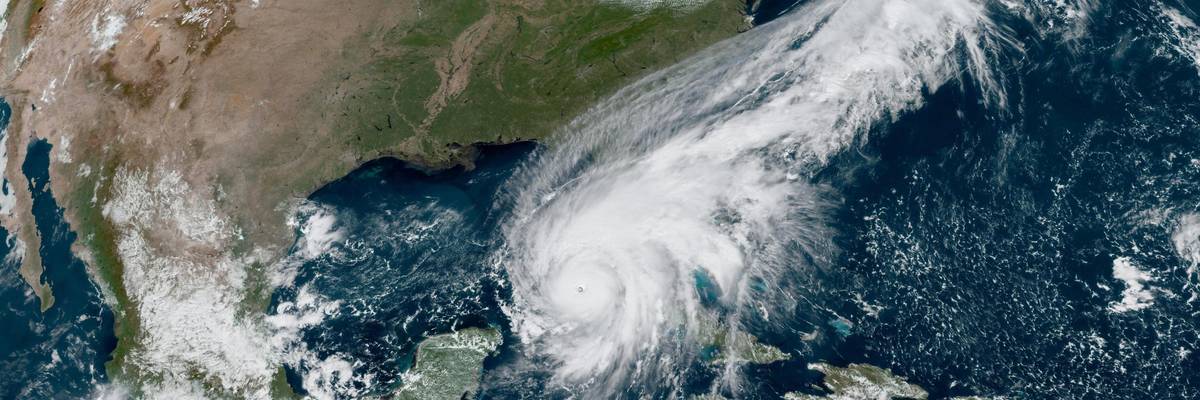
Imagery from NOAA's GOES-16 satellite shows Hurricane Ian spinning northward from Cuba toward Florida on September 27, 2022. (Photo: NOAA)
Government officials and extreme weather experts on Tuesday warned Floridians to brace for impact from Ian, the first hurricane to threaten the Tampa Bay area in a century and the latest in what scientists say will be an era of more frequent and stronger storms due to the climate emergency.
"If you're good at prayer put Tampa on your list--the worst-case scenarios for Ian are haunting."
As Ian's eye passed over the northern coast of Cuba--where the Category 3 storm left around a million people without electricity--the U.S. National Oceanic and Atmospheric Administration (NOAA) said that "life-threatening storm surge looks increasingly likely along much of the [Florida] west coast where a storm surge warning is in effect, with the highest risk from Fort Myers to the Tampa Bay region. Listen to advice given by local officials and follow evacuation orders."
Hurricane and tropical storm warnings and watches were in effect throughout nearly all of Florida and as far north as South Carolina as Ian moved into the Gulf of Mexico, with local weather reports forecasting the storm will intensify into a Category 4--the second-strongest classification on the Saffir-Simpson scale, which is based on wind speed. Ian is expected to make landfall as a Category 4 storm somewhere between Tampa and Fort Meyers on Wednesday afternoon.
Bill McKibben, co-founder of the climate action group 350.org, tweeted: "If you're good at prayer put Tampa on your list--the worst-case scenarios for Ian are haunting. Too much heat in the ocean!"
Climatologist Michael E. Mann is likewise "worried about [the] worst-case scenario with Ian."
"Tampa's long been [a] sitting duck for catastrophic storm surge and has dodged several bullets," he tweeted. "Might not be so lucky this time."
Predicted storm surges ranged from 2-4 feet in the Keys and north of the Anclote River along Florida's Gulf of Mexico coast to 8-12 feet in the Tampa Bay area. Additionally, NOAA warned people along the Atlantic coast from just south of Cape Canaveral to Long Bay in South Carolina to prepare for possible storm surges of 1-4 feet, depending on the area.
The last time the Tampa Bay area took a direct hit from a hurricane, the year was 1921 and the population was a little over 100,000. Today, more than three million people live in the nation's 18th-largest metropolitan area, raising fears regarding the readiness of a populace unaccustomed to hurricanes. Those concerns have been amplified amid reports that Hurricane Fiona caught communities from storm-seasoned Puerto Rico to Canada off guard in recent days.
Those at particular risk include elderly people--especially those with electric-powered medical devices--and the unhoused, whose population has surged along with area rent prices during the Covid-19 pandemic.
Even if the area dodges yet another proverbial bullet and avoids the worst of Ian, rising sea levels caused by global heating mean local waters are projected to rise by as much as 2.5 feet by 2050 and by as much as eight feet by century's end, according to the Tampa Bay Climate Science Advisory Panel.
"Make no mistake," National Ocean Service Director Nicole LeBoeuf said in an interview with WUSF earlier this year, "sea level rise is upon us."
Beginning in January, the Tampa Bay Times published a series of articles on the region's warmer, wetter future. One of the articles warned that it won't take the "perfect storm" to wreak chaos throughout the area.
"What's going to be the Achilles' heel of Tampa, what is going to really surprise Tampa, is not a [Category] 5," National Hurricane Center storm surge specialist Jamie Rhome said, but rather "a big, sloppy Category 1 or 2."
Dear Common Dreams reader, It’s been nearly 30 years since I co-founded Common Dreams with my late wife, Lina Newhouser. We had the radical notion that journalism should serve the public good, not corporate profits. It was clear to us from the outset what it would take to build such a project. No paid advertisements. No corporate sponsors. No millionaire publisher telling us what to think or do. Many people said we wouldn't last a year, but we proved those doubters wrong. Together with a tremendous team of journalists and dedicated staff, we built an independent media outlet free from the constraints of profits and corporate control. Our mission has always been simple: To inform. To inspire. To ignite change for the common good. Building Common Dreams was not easy. Our survival was never guaranteed. When you take on the most powerful forces—Wall Street greed, fossil fuel industry destruction, Big Tech lobbyists, and uber-rich oligarchs who have spent billions upon billions rigging the economy and democracy in their favor—the only bulwark you have is supporters who believe in your work. But here’s the urgent message from me today. It's never been this bad out there. And it's never been this hard to keep us going. At the very moment Common Dreams is most needed, the threats we face are intensifying. We need your support now more than ever. We don't accept corporate advertising and never will. We don't have a paywall because we don't think people should be blocked from critical news based on their ability to pay. Everything we do is funded by the donations of readers like you. When everyone does the little they can afford, we are strong. But if that support retreats or dries up, so do we. Will you donate now to make sure Common Dreams not only survives but thrives? —Craig Brown, Co-founder |
Government officials and extreme weather experts on Tuesday warned Floridians to brace for impact from Ian, the first hurricane to threaten the Tampa Bay area in a century and the latest in what scientists say will be an era of more frequent and stronger storms due to the climate emergency.
"If you're good at prayer put Tampa on your list--the worst-case scenarios for Ian are haunting."
As Ian's eye passed over the northern coast of Cuba--where the Category 3 storm left around a million people without electricity--the U.S. National Oceanic and Atmospheric Administration (NOAA) said that "life-threatening storm surge looks increasingly likely along much of the [Florida] west coast where a storm surge warning is in effect, with the highest risk from Fort Myers to the Tampa Bay region. Listen to advice given by local officials and follow evacuation orders."
Hurricane and tropical storm warnings and watches were in effect throughout nearly all of Florida and as far north as South Carolina as Ian moved into the Gulf of Mexico, with local weather reports forecasting the storm will intensify into a Category 4--the second-strongest classification on the Saffir-Simpson scale, which is based on wind speed. Ian is expected to make landfall as a Category 4 storm somewhere between Tampa and Fort Meyers on Wednesday afternoon.
Bill McKibben, co-founder of the climate action group 350.org, tweeted: "If you're good at prayer put Tampa on your list--the worst-case scenarios for Ian are haunting. Too much heat in the ocean!"
Climatologist Michael E. Mann is likewise "worried about [the] worst-case scenario with Ian."
"Tampa's long been [a] sitting duck for catastrophic storm surge and has dodged several bullets," he tweeted. "Might not be so lucky this time."
Predicted storm surges ranged from 2-4 feet in the Keys and north of the Anclote River along Florida's Gulf of Mexico coast to 8-12 feet in the Tampa Bay area. Additionally, NOAA warned people along the Atlantic coast from just south of Cape Canaveral to Long Bay in South Carolina to prepare for possible storm surges of 1-4 feet, depending on the area.
The last time the Tampa Bay area took a direct hit from a hurricane, the year was 1921 and the population was a little over 100,000. Today, more than three million people live in the nation's 18th-largest metropolitan area, raising fears regarding the readiness of a populace unaccustomed to hurricanes. Those concerns have been amplified amid reports that Hurricane Fiona caught communities from storm-seasoned Puerto Rico to Canada off guard in recent days.
Those at particular risk include elderly people--especially those with electric-powered medical devices--and the unhoused, whose population has surged along with area rent prices during the Covid-19 pandemic.
Even if the area dodges yet another proverbial bullet and avoids the worst of Ian, rising sea levels caused by global heating mean local waters are projected to rise by as much as 2.5 feet by 2050 and by as much as eight feet by century's end, according to the Tampa Bay Climate Science Advisory Panel.
"Make no mistake," National Ocean Service Director Nicole LeBoeuf said in an interview with WUSF earlier this year, "sea level rise is upon us."
Beginning in January, the Tampa Bay Times published a series of articles on the region's warmer, wetter future. One of the articles warned that it won't take the "perfect storm" to wreak chaos throughout the area.
"What's going to be the Achilles' heel of Tampa, what is going to really surprise Tampa, is not a [Category] 5," National Hurricane Center storm surge specialist Jamie Rhome said, but rather "a big, sloppy Category 1 or 2."