
Taking a cue from Washington Gov. Jay Inslee, an outspoken climate action advocate who this week referred to the wildfires which have burned through hundreds of thousands of acres in his state as "climate fires," two New York Times journalists on Friday offered a visual of how the climate crisis is expected to affect every part of the United States.
Polls have shown that while Americans are increasingly concerned about the climate, a majority of them feel certain that their lives won't be directly affected by the crisis which has been linked to extreme weather events.
Research published earlier this month by the Yale Program on Climate Communication showed that while significant majorities of Americans agree with the scientific consensus that climate change is happening--and is caused mostly by human activities--only 43% of people in the U.S. think the crisis will affect them personally.
Majorities of respondents said they believed that the crisis would affect plants and animals, other people in the U.S., and people in other countries.
But at the Times, visual journalists Stuart A. Thompson and Yaryna Serkez compiled data from risk analysis firm Four Twenty Seven which shows that every county in the nation faces the risk of extreme weather events that are linked to the climate crisis.
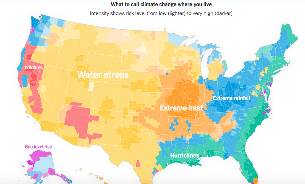
Nearly 170 million people live in areas at high risk for water stress or drought, according to the Times. More than a dozen states across the Midwest and western states contain areas that are at "high" or "very high" risk for water stress.
Hurricanes threaten the second-largest number of people in the U.S., with 104 million people living in areas at high risk for extreme storms.
Many places in the U.S. face high risk of multiple extreme weather events; Sonoma County in Northern California is at highest risk for wildfires and extreme rainfall, but also faces a medium-level risk of water stress and extreme heat. On the East Coast, Lincoln County, Maine is at a very high risk for extreme rainfall and a high risk for both sea level rise and hurricanes.
"Looking at the most significant climate threat unfolding in your own backyard" may help Americans to confront the reality that all of these events are part of the climate crisis, Thompson and Serkez wrote. "Thinking this way transforms the West Coast's raging wildfires into 'climate fires.' The Gulf Coast wouldn't live under the annual threat of floods but of 'climate floods.' Those are caused by ever more severe 'climate hurricanes.' The Midwest suffers its own 'climate droughts,' which threaten water supplies and endanger crops."
The article comes days after Inslee, facing fires in his state which destroyed 80% of one town and threatened Washington's apple crops, told George Stephanopoulos the crisis was directly linked to the climate emergency.
"These are not just wildfires, these are climate fires," Inslee said.
In the map created by the Times, Washington is identified as being at only medium risk of wildfires.
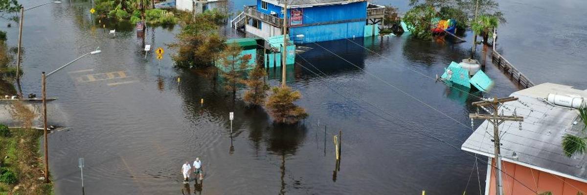
The Times also published the map as Hurricane Sally approached North Carolina and Virginia after flooding parts of the Gulf Coast, and as a new tropical depression formed in the Gulf of Mexico.
Taking a cue from Washington Gov. Jay Inslee, an outspoken climate action advocate who this week referred to the wildfires which have burned through hundreds of thousands of acres in his state as "climate fires," two New York Times journalists on Friday offered a visual of how the climate crisis is expected to affect every part of the United States.
Polls have shown that while Americans are increasingly concerned about the climate, a majority of them feel certain that their lives won't be directly affected by the crisis which has been linked to extreme weather events.
Research published earlier this month by the Yale Program on Climate Communication showed that while significant majorities of Americans agree with the scientific consensus that climate change is happening--and is caused mostly by human activities--only 43% of people in the U.S. think the crisis will affect them personally.
Majorities of respondents said they believed that the crisis would affect plants and animals, other people in the U.S., and people in other countries.
But at the Times, visual journalists Stuart A. Thompson and Yaryna Serkez compiled data from risk analysis firm Four Twenty Seven which shows that every county in the nation faces the risk of extreme weather events that are linked to the climate crisis.
Nearly 170 million people live in areas at high risk for water stress or drought, according to the Times. More than a dozen states across the Midwest and western states contain areas that are at "high" or "very high" risk for water stress.
Hurricanes threaten the second-largest number of people in the U.S., with 104 million people living in areas at high risk for extreme storms.
Many places in the U.S. face high risk of multiple extreme weather events; Sonoma County in Northern California is at highest risk for wildfires and extreme rainfall, but also faces a medium-level risk of water stress and extreme heat. On the East Coast, Lincoln County, Maine is at a very high risk for extreme rainfall and a high risk for both sea level rise and hurricanes.
"Looking at the most significant climate threat unfolding in your own backyard" may help Americans to confront the reality that all of these events are part of the climate crisis, Thompson and Serkez wrote. "Thinking this way transforms the West Coast's raging wildfires into 'climate fires.' The Gulf Coast wouldn't live under the annual threat of floods but of 'climate floods.' Those are caused by ever more severe 'climate hurricanes.' The Midwest suffers its own 'climate droughts,' which threaten water supplies and endanger crops."
The article comes days after Inslee, facing fires in his state which destroyed 80% of one town and threatened Washington's apple crops, told George Stephanopoulos the crisis was directly linked to the climate emergency.
"These are not just wildfires, these are climate fires," Inslee said.
In the map created by the Times, Washington is identified as being at only medium risk of wildfires.
The Times also published the map as Hurricane Sally approached North Carolina and Virginia after flooding parts of the Gulf Coast, and as a new tropical depression formed in the Gulf of Mexico.