SUBSCRIBE TO OUR FREE NEWSLETTER
Daily news & progressive opinion—funded by the people, not the corporations—delivered straight to your inbox.
5
#000000
#FFFFFF
To donate by check, phone, or other method, see our More Ways to Give page.
Daily news & progressive opinion—funded by the people, not the corporations—delivered straight to your inbox.
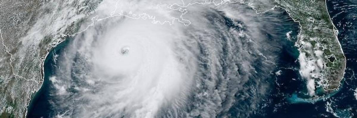
Satellite imagery from NOAA taken August 26, 2020, shows Hurricane Laura in the Gulf of Mexico. (Image: NOAA)
This is a developing story. Check back for possible updates.
The National Hurricane Center warned Wednesday that "little time remains to protect life and property" as Hurricane Laura--"an extremely dangerous Category 4 hurricane"--neared landfall and was poised to bring an "unsurvivable storm surge" for parts of Texas and Louisiana.
The 2:00 pm warning from the center came hours after a morning message conveying the possible dangers of the storm and the urgency with which residents should act, as Laura is expected to make landfall in Texas and Louisiana along the Gulft coast Wednesday night. From the center:
Unsurvivable storm surge with large and destructive waves will cause catastrophic damage from Sea Rim State Park, Texas, to Intracoastal City, Louisiana, including Calcasieu and Sabine Lakes. This surge could penetrate up to 30 miles inland from the immediate coastline. Only a few hours remain to protect life and property and all actions should be rushed to completion.
Forecasters said that catastrophic wind damage was expected "where Laura's eyewall makes landfall." Hurricane-force winds were expected to "spread well inland."
Areas of eastern Texas, Louisiana, and Arkansas should also prepare for flash flooding.
Explaining the storm's rapid strengthening, meteorologist Jeff Masters wrote at Yale Climate Connections:
Laura rapidly intensified by an impressive 50 mph in the 24 hours ending at 11 a.m. EDT Wednesday, with the winds rising from 75 mph to 125 mph and the pressure falling from 990 mb to 956 mb. This far exceeds the definition of rapid intensification, which is a 24 mb drop in 24 hours. Buoy 42395, located just east of Laura's eye on Wednesday morning, reported sustained winds of up to 76 mph, wind gusts as high as 107 mph, and a wave height of 37 feet (11 meters).
Climate activist and author Bill McKibben put the storm in the context of the climate crisis, tweeting Wednesday, "It is terrifying to watch the speed with which Hurricane Laura is intensifying."
"The hot waters of the Gulf are an endless source of destructive power," wrote McKibben.
Dear Common Dreams reader, It’s been nearly 30 years since I co-founded Common Dreams with my late wife, Lina Newhouser. We had the radical notion that journalism should serve the public good, not corporate profits. It was clear to us from the outset what it would take to build such a project. No paid advertisements. No corporate sponsors. No millionaire publisher telling us what to think or do. Many people said we wouldn't last a year, but we proved those doubters wrong. Together with a tremendous team of journalists and dedicated staff, we built an independent media outlet free from the constraints of profits and corporate control. Our mission has always been simple: To inform. To inspire. To ignite change for the common good. Building Common Dreams was not easy. Our survival was never guaranteed. When you take on the most powerful forces—Wall Street greed, fossil fuel industry destruction, Big Tech lobbyists, and uber-rich oligarchs who have spent billions upon billions rigging the economy and democracy in their favor—the only bulwark you have is supporters who believe in your work. But here’s the urgent message from me today. It's never been this bad out there. And it's never been this hard to keep us going. At the very moment Common Dreams is most needed, the threats we face are intensifying. We need your support now more than ever. We don't accept corporate advertising and never will. We don't have a paywall because we don't think people should be blocked from critical news based on their ability to pay. Everything we do is funded by the donations of readers like you. When everyone does the little they can afford, we are strong. But if that support retreats or dries up, so do we. Will you donate now to make sure Common Dreams not only survives but thrives? —Craig Brown, Co-founder |
This is a developing story. Check back for possible updates.
The National Hurricane Center warned Wednesday that "little time remains to protect life and property" as Hurricane Laura--"an extremely dangerous Category 4 hurricane"--neared landfall and was poised to bring an "unsurvivable storm surge" for parts of Texas and Louisiana.
The 2:00 pm warning from the center came hours after a morning message conveying the possible dangers of the storm and the urgency with which residents should act, as Laura is expected to make landfall in Texas and Louisiana along the Gulft coast Wednesday night. From the center:
Unsurvivable storm surge with large and destructive waves will cause catastrophic damage from Sea Rim State Park, Texas, to Intracoastal City, Louisiana, including Calcasieu and Sabine Lakes. This surge could penetrate up to 30 miles inland from the immediate coastline. Only a few hours remain to protect life and property and all actions should be rushed to completion.
Forecasters said that catastrophic wind damage was expected "where Laura's eyewall makes landfall." Hurricane-force winds were expected to "spread well inland."
Areas of eastern Texas, Louisiana, and Arkansas should also prepare for flash flooding.
Explaining the storm's rapid strengthening, meteorologist Jeff Masters wrote at Yale Climate Connections:
Laura rapidly intensified by an impressive 50 mph in the 24 hours ending at 11 a.m. EDT Wednesday, with the winds rising from 75 mph to 125 mph and the pressure falling from 990 mb to 956 mb. This far exceeds the definition of rapid intensification, which is a 24 mb drop in 24 hours. Buoy 42395, located just east of Laura's eye on Wednesday morning, reported sustained winds of up to 76 mph, wind gusts as high as 107 mph, and a wave height of 37 feet (11 meters).
Climate activist and author Bill McKibben put the storm in the context of the climate crisis, tweeting Wednesday, "It is terrifying to watch the speed with which Hurricane Laura is intensifying."
"The hot waters of the Gulf are an endless source of destructive power," wrote McKibben.