
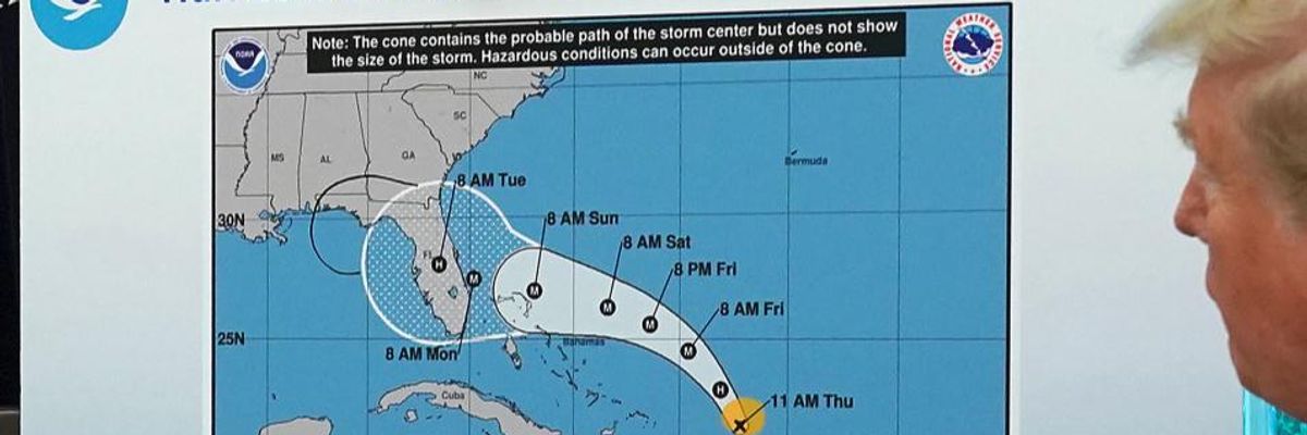
U.S. President Donald Trump (R) references a map held by acting Homeland Security Secretary Kevin McAleenan while talking to reporters following a briefing from officials about Hurricane Dorian in the Oval Office at the White House September 04, 2019 in Washington, DC. The map was a forecast from August 29 and appears to have been altered by a black marker to extend the hurricane's range to include Alabama. (Photo: Chip Somodevilla/Getty Images)
"If This Wasn't So Dangerous I'd Be Laughing": Trump Presents Outdated Dorian Forecast Map With Alabama Circled With Sharpie
"It is a violation of federal law to falsify a National Weather Service forecast and pass it off as official, as President Trump did here."
Seemingly loath to admit his erroneous claim that the state of Alabama would face a direct hit from Hurricane Dorian--the powerful storm that devastated the Bahamas in recent days and is now threatening the coasts of Florida, Georgia, and the Carolinas--President Donald Trump was again the subject of widespread online ridicule on Wednesday after he presented a government-generated map with Alabama additionally circled with a Sharpie pen.
In a tweet that rapidly gained over ten thousand likes and retweets, journalist Dennis Mersereau pointed out how obviously the map Trump pointed to during a White House statement was altered from the original:
As the Washington Post reports:
In a White House video released Wednesday, Trump displays a modified National Hurricane Center "Cone of Uncertainty" forecast, dated from 11 a.m. on Aug. 29, indicating Alabama would in fact be impacted. The graphic appears to have been altered with a Sharpie to indicate a risk the storm would move into Alabama from Florida.
"We had, actually, our original chart was that it was going to be hit -- hitting Florida directly," Trump said as he displayed the graphic from Aug. 29, which now includes an added appendage extending the cone into Alabama. "That was the original chart," Trump said. "It could've, uh, was going towards the Gulf," Trump explained in the video.
According to Mersereau, citing a U.S. statute, "It is a violation of federal law to falsify a National Weather Service forecast and pass it off as official, as President Trump did here."
Asked subsequently about the markings on the map, Trump told reporters he didn't know where the marks came from:
Last week, federal officials with the National Weather Service were forced to issue a public correction after Trump declared publicly that Alabama was at risk from the storm:
However, even after the NWS corrected the president's remarks, Trump did it again.
As video and photographs of the altered map spread on social media Wednesday--especially with the real storm wreaking extreme havoc from the Bahamas to the Carolinas--critics of the president unleashed over his self-indulgent, narcissistic focus on Alabama.
An Urgent Message From Our Co-Founder
Dear Common Dreams reader, It’s been nearly 30 years since I co-founded Common Dreams with my late wife, Lina Newhouser. We had the radical notion that journalism should serve the public good, not corporate profits. It was clear to us from the outset what it would take to build such a project. No paid advertisements. No corporate sponsors. No millionaire publisher telling us what to think or do. Many people said we wouldn't last a year, but we proved those doubters wrong. Together with a tremendous team of journalists and dedicated staff, we built an independent media outlet free from the constraints of profits and corporate control. Our mission has always been simple: To inform. To inspire. To ignite change for the common good. Building Common Dreams was not easy. Our survival was never guaranteed. When you take on the most powerful forces—Wall Street greed, fossil fuel industry destruction, Big Tech lobbyists, and uber-rich oligarchs who have spent billions upon billions rigging the economy and democracy in their favor—the only bulwark you have is supporters who believe in your work. But here’s the urgent message from me today. It's never been this bad out there. And it's never been this hard to keep us going. At the very moment Common Dreams is most needed, the threats we face are intensifying. We need your support now more than ever. We don't accept corporate advertising and never will. We don't have a paywall because we don't think people should be blocked from critical news based on their ability to pay. Everything we do is funded by the donations of readers like you. When everyone does the little they can afford, we are strong. But if that support retreats or dries up, so do we. Will you donate now to make sure Common Dreams not only survives but thrives? —Craig Brown, Co-founder |
Seemingly loath to admit his erroneous claim that the state of Alabama would face a direct hit from Hurricane Dorian--the powerful storm that devastated the Bahamas in recent days and is now threatening the coasts of Florida, Georgia, and the Carolinas--President Donald Trump was again the subject of widespread online ridicule on Wednesday after he presented a government-generated map with Alabama additionally circled with a Sharpie pen.
In a tweet that rapidly gained over ten thousand likes and retweets, journalist Dennis Mersereau pointed out how obviously the map Trump pointed to during a White House statement was altered from the original:
As the Washington Post reports:
In a White House video released Wednesday, Trump displays a modified National Hurricane Center "Cone of Uncertainty" forecast, dated from 11 a.m. on Aug. 29, indicating Alabama would in fact be impacted. The graphic appears to have been altered with a Sharpie to indicate a risk the storm would move into Alabama from Florida.
"We had, actually, our original chart was that it was going to be hit -- hitting Florida directly," Trump said as he displayed the graphic from Aug. 29, which now includes an added appendage extending the cone into Alabama. "That was the original chart," Trump said. "It could've, uh, was going towards the Gulf," Trump explained in the video.
According to Mersereau, citing a U.S. statute, "It is a violation of federal law to falsify a National Weather Service forecast and pass it off as official, as President Trump did here."
Asked subsequently about the markings on the map, Trump told reporters he didn't know where the marks came from:
Last week, federal officials with the National Weather Service were forced to issue a public correction after Trump declared publicly that Alabama was at risk from the storm:
However, even after the NWS corrected the president's remarks, Trump did it again.
As video and photographs of the altered map spread on social media Wednesday--especially with the real storm wreaking extreme havoc from the Bahamas to the Carolinas--critics of the president unleashed over his self-indulgent, narcissistic focus on Alabama.