SUBSCRIBE TO OUR FREE NEWSLETTER
Daily news & progressive opinion—funded by the people, not the corporations—delivered straight to your inbox.
5
#000000
#FFFFFF
To donate by check, phone, or other method, see our More Ways to Give page.
Daily news & progressive opinion—funded by the people, not the corporations—delivered straight to your inbox.
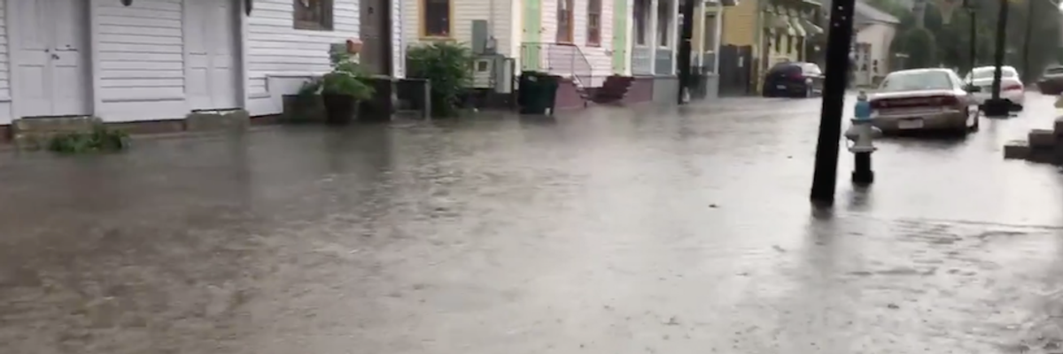
Annunciation Street in New Orleans was flooded Wednesday morning. (Image: screenshot)
While the Louisiana coast braces for what's expected to be the first formed hurricane of the 2019 season, predicted to make landfall Saturday, New Orleans on Wednesday endured torrential downpours of up to 10 inches in parts of the city.
The Mississippi River is predicted to crest at 20 feet on Saturday, which, as meteorologist Eric Holthaus pointed out, is the height of New Orleans' levees.
The flooding in New Orleans Wednesday morning was so bad that people were using kayaks to navigate city streets.
Some parts of downtown endured up to 10 inches of rain in a matter of hours while the cities of Harvey, Metairie, and Gretna were all reporting flooding.
Barry, the second named tropical depression of the season that NOAA is giving a "near 100 percent chance" of forming into a hurricane, is predicted to slam into the coast on Saturday to the west of New Orleans. Storm surge is expected to be between three and five feet, and the storm is predicted to bring rainfall of at least 18 inches.
Barry was formed out of Midwestern rainstorms, as Earther's Brian Kahn reported Tuesday:
A tropical storm getting its beginnings in Missouri may seem odd, but Space City Weather meteorologist Matt Lanza told Earther in a Twitter direct message that it "happens more often than people would assume." Lanza pointed to a tweet from Michael Lowry, a tropical storm expert who works at the Federal Emergency Management Agency, noting that while 50-60 percent of Atlantic tropical cyclones start near Africa as series of thunderstorms, that still leaves a good chunk with other origins. Storms with screwball starts like potential Tropical Storm Barry have happened before.
Wednesday's New Orleans rainfall and Barry are both indicators of the climate crisis, Kahn said on Twitter.
"The U.S. just had its wettest 12-month period on record beating the previous record set last month which beat the record set the month before," Kahn said, citing NOAA statistics.
NOAA released a report Wednesday which shows how high tide flooding events increased in 2018, and are expected to continue to increase in 2019.
Holthaus, in a piece for The New Republic, noted that the new reality of the climate crisis and its effects on the planet are just beginning to be understood.
"Overlapping extreme-weather events aren't just a New Orleans problem," wrote Holthaus. "In November, a team of researchers found that unless carbon emissions are greatly reduced, by the end of the century many parts of the world would face overlapping disasters most of the time."
Dear Common Dreams reader, It’s been nearly 30 years since I co-founded Common Dreams with my late wife, Lina Newhouser. We had the radical notion that journalism should serve the public good, not corporate profits. It was clear to us from the outset what it would take to build such a project. No paid advertisements. No corporate sponsors. No millionaire publisher telling us what to think or do. Many people said we wouldn't last a year, but we proved those doubters wrong. Together with a tremendous team of journalists and dedicated staff, we built an independent media outlet free from the constraints of profits and corporate control. Our mission has always been simple: To inform. To inspire. To ignite change for the common good. Building Common Dreams was not easy. Our survival was never guaranteed. When you take on the most powerful forces—Wall Street greed, fossil fuel industry destruction, Big Tech lobbyists, and uber-rich oligarchs who have spent billions upon billions rigging the economy and democracy in their favor—the only bulwark you have is supporters who believe in your work. But here’s the urgent message from me today. It's never been this bad out there. And it's never been this hard to keep us going. At the very moment Common Dreams is most needed, the threats we face are intensifying. We need your support now more than ever. We don't accept corporate advertising and never will. We don't have a paywall because we don't think people should be blocked from critical news based on their ability to pay. Everything we do is funded by the donations of readers like you. When everyone does the little they can afford, we are strong. But if that support retreats or dries up, so do we. Will you donate now to make sure Common Dreams not only survives but thrives? —Craig Brown, Co-founder |
While the Louisiana coast braces for what's expected to be the first formed hurricane of the 2019 season, predicted to make landfall Saturday, New Orleans on Wednesday endured torrential downpours of up to 10 inches in parts of the city.
The Mississippi River is predicted to crest at 20 feet on Saturday, which, as meteorologist Eric Holthaus pointed out, is the height of New Orleans' levees.
The flooding in New Orleans Wednesday morning was so bad that people were using kayaks to navigate city streets.
Some parts of downtown endured up to 10 inches of rain in a matter of hours while the cities of Harvey, Metairie, and Gretna were all reporting flooding.
Barry, the second named tropical depression of the season that NOAA is giving a "near 100 percent chance" of forming into a hurricane, is predicted to slam into the coast on Saturday to the west of New Orleans. Storm surge is expected to be between three and five feet, and the storm is predicted to bring rainfall of at least 18 inches.
Barry was formed out of Midwestern rainstorms, as Earther's Brian Kahn reported Tuesday:
A tropical storm getting its beginnings in Missouri may seem odd, but Space City Weather meteorologist Matt Lanza told Earther in a Twitter direct message that it "happens more often than people would assume." Lanza pointed to a tweet from Michael Lowry, a tropical storm expert who works at the Federal Emergency Management Agency, noting that while 50-60 percent of Atlantic tropical cyclones start near Africa as series of thunderstorms, that still leaves a good chunk with other origins. Storms with screwball starts like potential Tropical Storm Barry have happened before.
Wednesday's New Orleans rainfall and Barry are both indicators of the climate crisis, Kahn said on Twitter.
"The U.S. just had its wettest 12-month period on record beating the previous record set last month which beat the record set the month before," Kahn said, citing NOAA statistics.
NOAA released a report Wednesday which shows how high tide flooding events increased in 2018, and are expected to continue to increase in 2019.
Holthaus, in a piece for The New Republic, noted that the new reality of the climate crisis and its effects on the planet are just beginning to be understood.
"Overlapping extreme-weather events aren't just a New Orleans problem," wrote Holthaus. "In November, a team of researchers found that unless carbon emissions are greatly reduced, by the end of the century many parts of the world would face overlapping disasters most of the time."