SUBSCRIBE TO OUR FREE NEWSLETTER
Daily news & progressive opinion—funded by the people, not the corporations—delivered straight to your inbox.
5
#000000
#FFFFFF
To donate by check, phone, or other method, see our More Ways to Give page.
The records, which were obtained by way of a Freedom of Information Act (FOIA) lawsuit against the Federal Aviation Administration (FAA), come from state and local law enforcement agencies, universities and--for the first time--three branches of the U.S. military: the Air Force, Marine Corps, and DARPA (Defense Advanced Research Projects Agency), the group writes on their Deeplinks blog.
According to the records, the Air Force has been testing out a variety of drones, from the smaller, hand-launched Raven, Puma and Wasp drones to the larger Predator and Reaper models largely responsible for countless civilian and foreign military deaths.
Breaking down the shocking capabilities of the various machines, Deeplinks writes that the technologies "takes surveillance to a whole new level." They continue:
According to a recent Gizmodo article, the Puma AE ("All Environment") drone can land anywhere, "either in tight city streets or onto a water surface if the mission dictates, even after a near-vertical 'deep stall' final approach." Another drone, Insitu's ScanEagle, which the Air Force has flown near Virginia Beach, sports an "inertial-stabilized camera turret, [that] allows for the tracking of a target of interest for extended periods of time, even when the target is moving and the aircraft nose is seldom pointed at the target." Boeing's A160 Hummingbird, which the Air Force has flown near Victorville, California, is capable of staying in the air for 16-24 hours at a time and carries a gigapixel camera and a "Forester foliage-penetration radar" system designed by the Defense Advanced Research Projects Agency (DARPA).
Perhaps the scariest is the technology carried by a Reaper drone the Air Force is flying near Lincoln, Nevada and in areas of California and Utah. This drone uses "Gorgon Stare" technology, which Wikipedia defines as "a spherical array of nine cameras attached to an aerial drone capable of capturing motion imagery of an entire city." This imagery "can then be analyzed by humans or an artificial intelligence, such as the Mind's Eye project" being developed by DARPA.
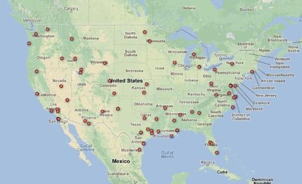
Also Wednesday, the watchdog group published a new map that tracks the location of drone flights across the United States.
The records, which were obtained by way of a Freedom of Information Act (FOIA) lawsuit against the Federal Aviation Administration (FAA), come from state and local law enforcement agencies, universities and--for the first time--three branches of the U.S. military: the Air Force, Marine Corps, and DARPA (Defense Advanced Research Projects Agency), the group writes on their Deeplinks blog.
According to the records, the Air Force has been testing out a variety of drones, from the smaller, hand-launched Raven, Puma and Wasp drones to the larger Predator and Reaper models largely responsible for countless civilian and foreign military deaths.
Breaking down the shocking capabilities of the various machines, Deeplinks writes that the technologies "takes surveillance to a whole new level." They continue:
According to a recent Gizmodo article, the Puma AE ("All Environment") drone can land anywhere, "either in tight city streets or onto a water surface if the mission dictates, even after a near-vertical 'deep stall' final approach." Another drone, Insitu's ScanEagle, which the Air Force has flown near Virginia Beach, sports an "inertial-stabilized camera turret, [that] allows for the tracking of a target of interest for extended periods of time, even when the target is moving and the aircraft nose is seldom pointed at the target." Boeing's A160 Hummingbird, which the Air Force has flown near Victorville, California, is capable of staying in the air for 16-24 hours at a time and carries a gigapixel camera and a "Forester foliage-penetration radar" system designed by the Defense Advanced Research Projects Agency (DARPA).
Perhaps the scariest is the technology carried by a Reaper drone the Air Force is flying near Lincoln, Nevada and in areas of California and Utah. This drone uses "Gorgon Stare" technology, which Wikipedia defines as "a spherical array of nine cameras attached to an aerial drone capable of capturing motion imagery of an entire city." This imagery "can then be analyzed by humans or an artificial intelligence, such as the Mind's Eye project" being developed by DARPA.
Also Wednesday, the watchdog group published a new map that tracks the location of drone flights across the United States.