

SUBSCRIBE TO OUR FREE NEWSLETTER
Daily news & progressive opinion—funded by the people, not the corporations—delivered straight to your inbox.
5
#000000
#FFFFFF
To donate by check, phone, or other method, see our More Ways to Give page.
Daily news & progressive opinion—funded by the people, not the corporations—delivered straight to your inbox.
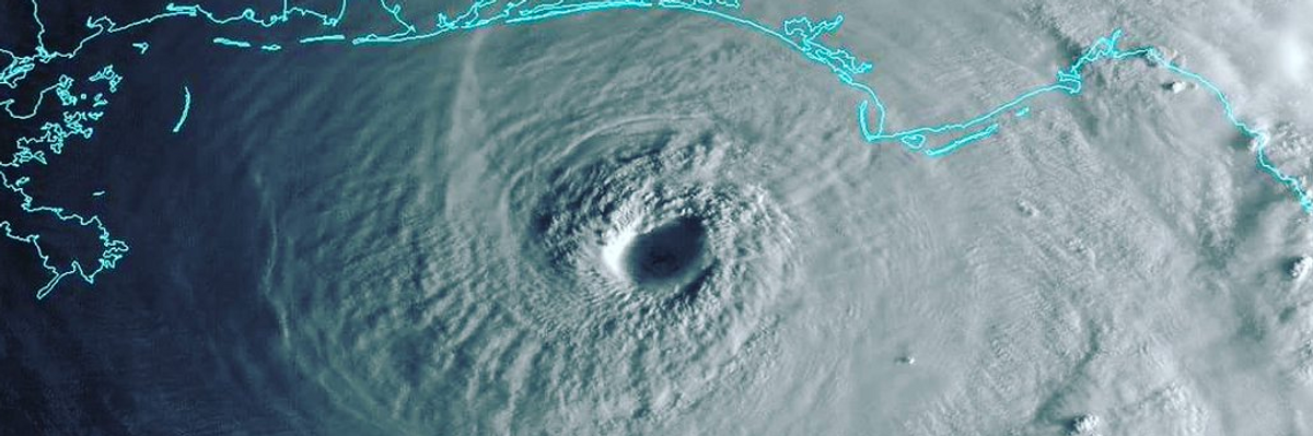
A satellite image of Hurricane Michael on Wednesday morning ahead of landfall expected in the coming hours. (Photo: MSFC/NASA)
As with many similar mega-storms in this age of climate change and extreme weather, an "ominous" Hurricane Michael is heading for U.S. landfall on Wednesday alongside grave warnings of destruction with weather experts and government officials raising last-minute alarms for people to seek shelter or flee vulnerable areas before the storm hits.
The National Hurricane Center said the powerful storm--officially upgraded to a Category 4 hurricane overnight with sustained winds of up to 140 mph and gusts of 185 mph--is expected to move across the northeastern Gulf of Mexico before making landfall in the Panhandle region of Florida in the afternoon, and then sweep inland to the northeast.
"We have a pit in our stomachs," National Hurricane Center Director Ken Graham said on Wednesday morning discussing the storm's approach on the Weather Channel.
"Hurricane Michael is a monstrous storm. The forecast keeps getting more dangerous," said Republican Gov. Rick Scott on Tuesday as he urged all residents in the storm's path to evacuate or seek safe shelter.
Outside experts and meteorologists added their concerns over the strength of the storm, especially as it gathered power ahead of landfall:
\u201cThis is the real deal. Hurricanes that intensify overnight just before reaching land are the worst nightmare of forecasters and emergency managers.\u201d— Bob Henson (@Bob Henson) 1539142157
\u201cHurricane #Michael -- now one of the strongest hurricanes ever to threaten Florida -- is THE SIZE of Florida.\n\nA truly historic storm.\nhttps://t.co/73wKTEMBk0\u201d— Eric Holthaus (@Eric Holthaus) 1539154928
\u201cExceptionally serious scenario unfolding this morning with #Michael as an intensifying category 4 #hurricane headed toward the coast - no one in that area has ever experienced a hurricane this strong there\u201d— Eric Blake \ud83c\udf00 (@Eric Blake \ud83c\udf00) 1539174892
\u201c#Michael is now a fierce Category 4 hurricane, with top sustained winds of 130 mph. It may strengthen even further before landfall. No Cat 4 landfall has occurred in the Florida Panhandle in 167 years of recordkeeping. https://t.co/hbdraUzrT2\u201d— Weather Underground (@Weather Underground) 1539153113
Donald Trump’s attacks on democracy, justice, and a free press are escalating — putting everything we stand for at risk. We believe a better world is possible, but we can’t get there without your support. Common Dreams stands apart. We answer only to you — our readers, activists, and changemakers — not to billionaires or corporations. Our independence allows us to cover the vital stories that others won’t, spotlighting movements for peace, equality, and human rights. Right now, our work faces unprecedented challenges. Misinformation is spreading, journalists are under attack, and financial pressures are mounting. As a reader-supported, nonprofit newsroom, your support is crucial to keep this journalism alive. Whatever you can give — $10, $25, or $100 — helps us stay strong and responsive when the world needs us most. Together, we’ll continue to build the independent, courageous journalism our movement relies on. Thank you for being part of this community. |
As with many similar mega-storms in this age of climate change and extreme weather, an "ominous" Hurricane Michael is heading for U.S. landfall on Wednesday alongside grave warnings of destruction with weather experts and government officials raising last-minute alarms for people to seek shelter or flee vulnerable areas before the storm hits.
The National Hurricane Center said the powerful storm--officially upgraded to a Category 4 hurricane overnight with sustained winds of up to 140 mph and gusts of 185 mph--is expected to move across the northeastern Gulf of Mexico before making landfall in the Panhandle region of Florida in the afternoon, and then sweep inland to the northeast.
"We have a pit in our stomachs," National Hurricane Center Director Ken Graham said on Wednesday morning discussing the storm's approach on the Weather Channel.
"Hurricane Michael is a monstrous storm. The forecast keeps getting more dangerous," said Republican Gov. Rick Scott on Tuesday as he urged all residents in the storm's path to evacuate or seek safe shelter.
Outside experts and meteorologists added their concerns over the strength of the storm, especially as it gathered power ahead of landfall:
\u201cThis is the real deal. Hurricanes that intensify overnight just before reaching land are the worst nightmare of forecasters and emergency managers.\u201d— Bob Henson (@Bob Henson) 1539142157
\u201cHurricane #Michael -- now one of the strongest hurricanes ever to threaten Florida -- is THE SIZE of Florida.\n\nA truly historic storm.\nhttps://t.co/73wKTEMBk0\u201d— Eric Holthaus (@Eric Holthaus) 1539154928
\u201cExceptionally serious scenario unfolding this morning with #Michael as an intensifying category 4 #hurricane headed toward the coast - no one in that area has ever experienced a hurricane this strong there\u201d— Eric Blake \ud83c\udf00 (@Eric Blake \ud83c\udf00) 1539174892
\u201c#Michael is now a fierce Category 4 hurricane, with top sustained winds of 130 mph. It may strengthen even further before landfall. No Cat 4 landfall has occurred in the Florida Panhandle in 167 years of recordkeeping. https://t.co/hbdraUzrT2\u201d— Weather Underground (@Weather Underground) 1539153113