
SUBSCRIBE TO OUR FREE NEWSLETTER
Daily news & progressive opinion—funded by the people, not the corporations—delivered straight to your inbox.
5
#000000
#FFFFFF
To donate by check, phone, or other method, see our More Ways to Give page.


Daily news & progressive opinion—funded by the people, not the corporations—delivered straight to your inbox.
A state of emergency https://news.yahoo.com/coastal-residents-told-way-ahead-superstorm-could...

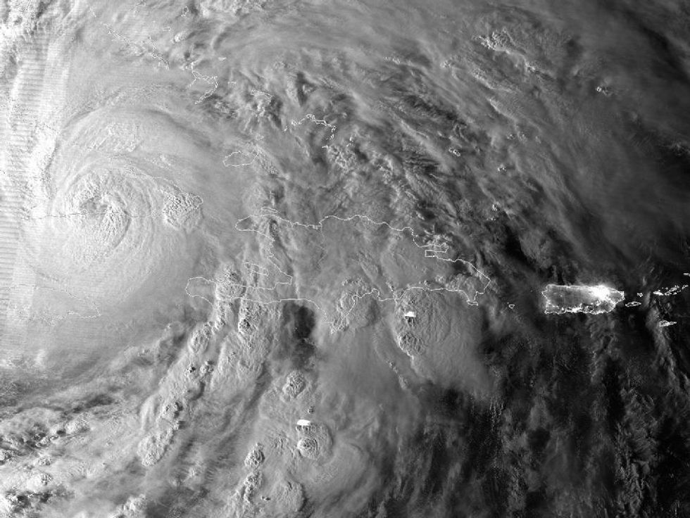
As of Sunday morning, Sandy had regained strength to a Category 1 hurricane, with 75 mph winds, about 260 miles southeast of Cape Hatteras, N.C., and moving northeast at 14 mph, according to the National Hurricane Center in Miami.
Sandy's massive width could make it the largest storm to hit the United States, according to the National Oceanic and Atmospheric Administration's website, and is expected to make official landfall by Monday evening.
Sandy could have a brutal impact on several major cities including Boston, New York, Washington, Baltimore, and Philadelphia, which make up one of the most densely populated regions of the country.
"We're looking at impact of greater than 50 to 60 million people," said Louis Uccellini, head of environmental prediction for the National Oceanic and Atmospheric Administration.
Unusual tides due to a full moon will make flooding far more likely, as the rough seas batter the coast. A life-threatening storm surge, or extremely elevated water, is expected, according to the National Hurricane Center. Water could surge 6-11 feet in the New York area and 4-8 feet elsewhere.
Extensive power outages are expected, and rainfall could cause significant flooding, even as it heads inland through Pennsylvania and upstate New York.
Governors of each state in Sandy's path ordered mandatory evacuations of vulnerable areas, and New York City officials have shut the subway and bus services for Sunday evening starting at 7 pm.
In New Jersey, hundreds of coastal residents started moving inland, ahead of the forced evacuation of the some 30,000 residents of Atlantic City beginning noon on Sunday.
In North Carolina's Outer Banks, a group of about 20 people has been forced to wait out the storm on uninhabited Portsmouth Island.
"We tried to get off the island and the ferry service shut down on us," said Bill Rowley, 49, of Rocky Mount, N.C.
Rowley told Associated Press that he could see 15-foot seas breaking over the island's dunes, enough to bring water to the island's interior, before the storm had officially hit.
"The size of this alone, affecting a heavily populated area, is going to be history making," said Jeff Masters, a hurricane specialist who writes a blog posted on the Weather Underground.
Grocery and hardware stores are selling out of supplies, as residents prepare for the worst.
As the storm barrels towards the frantic east coast, weather experts have begun relating the unusual freakishness of the storm to patterns of climate change, which have brought about a series of superstorms in recent years.
Stephen Lacey and Joe Romm at Think Progress write:
A confluence of factors are coming together to make the storm unprecedented. As Sandy moves through the Atlantic, it is expected to combine with an early winter storm from the continental U.S., causing pressure to drop -- potentially reaching pressure levels of a category 3 or 4 hurricane with winds over 115 miles per hour...Another factor under consideration is climate change. Like a baseball player on steroids, our climate system is breaking records at an unnatural pace.
Kevin Trenberth, former head of the Climate Analysis Section at the U.S. National Center for Atmospheric Research, has concluded that all superstorms are products of climate change:
The air is on average warmer and moister than it was prior to about 1970 and in turn has likely led to a 5-10 % effect on precipitation and storms that is greatly amplified in extremes. The warm moist air is readily advected onto land and caught up in weather systems as part of the hydrological cycle, where it contributes to more intense precipitation events that are widely observed to be occurring.
* * *
# # #
Dear Common Dreams reader, The U.S. is on a fast track to authoritarianism like nothing I've ever seen. Meanwhile, corporate news outlets are utterly capitulating to Trump, twisting their coverage to avoid drawing his ire while lining up to stuff cash in his pockets. That's why I believe that Common Dreams is doing the best and most consequential reporting that we've ever done. Our small but mighty team is a progressive reporting powerhouse, covering the news every day that the corporate media never will. Our mission has always been simple: To inform. To inspire. And to ignite change for the common good. Now here's the key piece that I want all our readers to understand: None of this would be possible without your financial support. That's not just some fundraising cliche. It's the absolute and literal truth. We don't accept corporate advertising and never will. We don't have a paywall because we don't think people should be blocked from critical news based on their ability to pay. Everything we do is funded by the donations of readers like you. Will you donate now to help power the nonprofit, independent reporting of Common Dreams? Thank you for being a vital member of our community. Together, we can keep independent journalism alive when it’s needed most. - Craig Brown, Co-founder |

As of Sunday morning, Sandy had regained strength to a Category 1 hurricane, with 75 mph winds, about 260 miles southeast of Cape Hatteras, N.C., and moving northeast at 14 mph, according to the National Hurricane Center in Miami.
Sandy's massive width could make it the largest storm to hit the United States, according to the National Oceanic and Atmospheric Administration's website, and is expected to make official landfall by Monday evening.
Sandy could have a brutal impact on several major cities including Boston, New York, Washington, Baltimore, and Philadelphia, which make up one of the most densely populated regions of the country.
"We're looking at impact of greater than 50 to 60 million people," said Louis Uccellini, head of environmental prediction for the National Oceanic and Atmospheric Administration.
Unusual tides due to a full moon will make flooding far more likely, as the rough seas batter the coast. A life-threatening storm surge, or extremely elevated water, is expected, according to the National Hurricane Center. Water could surge 6-11 feet in the New York area and 4-8 feet elsewhere.
Extensive power outages are expected, and rainfall could cause significant flooding, even as it heads inland through Pennsylvania and upstate New York.
Governors of each state in Sandy's path ordered mandatory evacuations of vulnerable areas, and New York City officials have shut the subway and bus services for Sunday evening starting at 7 pm.
In New Jersey, hundreds of coastal residents started moving inland, ahead of the forced evacuation of the some 30,000 residents of Atlantic City beginning noon on Sunday.
In North Carolina's Outer Banks, a group of about 20 people has been forced to wait out the storm on uninhabited Portsmouth Island.
"We tried to get off the island and the ferry service shut down on us," said Bill Rowley, 49, of Rocky Mount, N.C.
Rowley told Associated Press that he could see 15-foot seas breaking over the island's dunes, enough to bring water to the island's interior, before the storm had officially hit.
"The size of this alone, affecting a heavily populated area, is going to be history making," said Jeff Masters, a hurricane specialist who writes a blog posted on the Weather Underground.
Grocery and hardware stores are selling out of supplies, as residents prepare for the worst.
As the storm barrels towards the frantic east coast, weather experts have begun relating the unusual freakishness of the storm to patterns of climate change, which have brought about a series of superstorms in recent years.
Stephen Lacey and Joe Romm at Think Progress write:
A confluence of factors are coming together to make the storm unprecedented. As Sandy moves through the Atlantic, it is expected to combine with an early winter storm from the continental U.S., causing pressure to drop -- potentially reaching pressure levels of a category 3 or 4 hurricane with winds over 115 miles per hour...Another factor under consideration is climate change. Like a baseball player on steroids, our climate system is breaking records at an unnatural pace.
Kevin Trenberth, former head of the Climate Analysis Section at the U.S. National Center for Atmospheric Research, has concluded that all superstorms are products of climate change:
The air is on average warmer and moister than it was prior to about 1970 and in turn has likely led to a 5-10 % effect on precipitation and storms that is greatly amplified in extremes. The warm moist air is readily advected onto land and caught up in weather systems as part of the hydrological cycle, where it contributes to more intense precipitation events that are widely observed to be occurring.
* * *
# # #