
SUBSCRIBE TO OUR FREE NEWSLETTER
Daily news & progressive opinion—funded by the people, not the corporations—delivered straight to your inbox.
5
#000000
#FFFFFF
To donate by check, phone, or other method, see our More Ways to Give page.


Daily news & progressive opinion—funded by the people, not the corporations—delivered straight to your inbox.

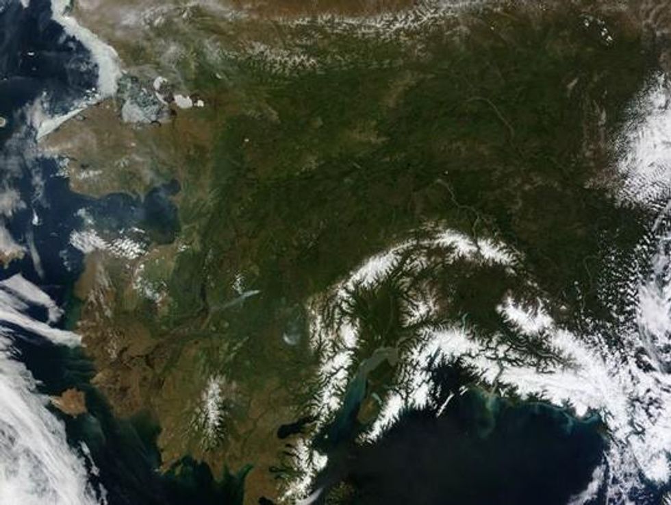
At first glance, it's just a great photo of nearly the entire state of Alaska on an exceptionally clear day. What could be the problem?
Well, turns out that photo shows an anomaly that some are fretting signifies yet another big shift in global climate - a shift toward the hot.
NASA writes (without saying "global warming"):
"The same ridge of high pressure that cleared Alaska's skies also brought stifling temperatures to many areas accustomed to chilly June days. Talkeetna, a town about 100 miles north of Anchorage, saw temperatures reach 96degF on June 17. Other towns in southern Alaska set all-time record highs, including Cordova, Valez, and Seward. The high temperatures also helped fuel wildfires and hastened the breakup of sea ice in the Chukchi Sea."
Oh, crap.
A writer for Slate rings the alarm bell the loudest:
The melt in Greenland and the high temperatures in Alaska may be more signs--like we needed more--of the reality of climate change. Even scarier is the fact that the climate models used before didn't predict this sort of thing. The climate is very complex, and it's hard to model it accurately. This is well-known and is why it's so hard to make long-term predictions.
But before the deniers crow that climatologists don't know what they're doing, note this well: The predictions made using these models almost always seem to underestimate the effects of climate change. That's true in this case, too. So it's not that the models are wrong and therefore climate change doesn't exist. It's that the models aren't perfect, and it's looking like things are worse than we thought.
Last year, the United State experienced its warmest year ever. And, globally 2012 was the 9th warmest year since 1850 with the years from 2001 to 2012 being among the top 13 warmest on record. The hottest year was 2010, when the average temperature was 58.2 degrees F
Now a study released Monday from the United Kingdom provides more fodder for freaking out over that picture of Alaska.
In a press release from the University of Sheffield, whose scientist led the research, jet stream changes were blamed for the big ice melt in Greenland ... and may signal another big year of heat and melting. (Note: "GrIS" = Greenland ice sheet)
Here's the main part of the news:
Atmospheric and oceanic climate forcing of the exceptional Greenland ice sheet surface melt in summer 2012
The research, published today in the International Journal of Climatology, clearly demonstrates that the record surface melting of the GrIS was mainly caused by highly unusual atmospheric circulation and jet stream changes, which were also responsible for last summer's unusually wet weather in England.
The analysis shows that ocean temperatures and Arctic sea-ice cover were relatively unimportant factors in causing the extra Greenland melt.
Professor Hanna said:
"The GrIS is a highly sensitive indicator of regional and global climate change, and has been undergoing rapid warming and mass loss during the last 5-20 years. Much attention has been given to the NASA announcement of record surface melting of the GrIS in mid-July 2012. This event was unprecedented in the satellite record of observations dating back to the 1970s and probably unlikely to have occurred previously for well over a century.
"Our research found that a 'heat dome' of warm southerly winds over the ice sheet led to widespread surface melting. These jet stream changes over Greenland do not seem to be well captured in the latest Intergovernmental Panel on Climate Change (IPCC) computer model predictions of climate change, and this may indicate a deficiency in these models. According to our current understanding, the unusual atmospheric circulation and consequent warm conditions of summer 2012 do not appear to be climatically representative of future 'average' summers predicted later this century.
"Taken together, our present results strongly suggest that the main forcing of the extreme GrIS surface melt in July 2012 was atmospheric, linked with changes in the summer North Atlantic Oscillation (NAO), Greenland Blocking Index (GBI, a high pressure system centred over Greenland) and polar jet stream which favoured southerly warm air advection along the western coast.
"The next five-10 years will reveal whether or not 2012 was a rare event resulting from the natural variability of the NAO or part of an emerging pattern of new extreme high melt years. Because such atmospheric, and resulting GrIS surface climate, changes are not well projected by the current generation of global climate models, it is currently very hard to predict future changes in Greenland climate. Yet it is crucial to understand such changes much better if we are to have any hope of reliably predicting future changes in GrIS mass balance, which is likely to be a dominant contributor to global sea-level change over the next 100-1000 years."
Dear Common Dreams reader, The U.S. is on a fast track to authoritarianism like nothing I've ever seen. Meanwhile, corporate news outlets are utterly capitulating to Trump, twisting their coverage to avoid drawing his ire while lining up to stuff cash in his pockets. That's why I believe that Common Dreams is doing the best and most consequential reporting that we've ever done. Our small but mighty team is a progressive reporting powerhouse, covering the news every day that the corporate media never will. Our mission has always been simple: To inform. To inspire. And to ignite change for the common good. Now here's the key piece that I want all our readers to understand: None of this would be possible without your financial support. That's not just some fundraising cliche. It's the absolute and literal truth. We don't accept corporate advertising and never will. We don't have a paywall because we don't think people should be blocked from critical news based on their ability to pay. Everything we do is funded by the donations of readers like you. Will you donate now to help power the nonprofit, independent reporting of Common Dreams? Thank you for being a vital member of our community. Together, we can keep independent journalism alive when it’s needed most. - Craig Brown, Co-founder |

At first glance, it's just a great photo of nearly the entire state of Alaska on an exceptionally clear day. What could be the problem?
Well, turns out that photo shows an anomaly that some are fretting signifies yet another big shift in global climate - a shift toward the hot.
NASA writes (without saying "global warming"):
"The same ridge of high pressure that cleared Alaska's skies also brought stifling temperatures to many areas accustomed to chilly June days. Talkeetna, a town about 100 miles north of Anchorage, saw temperatures reach 96degF on June 17. Other towns in southern Alaska set all-time record highs, including Cordova, Valez, and Seward. The high temperatures also helped fuel wildfires and hastened the breakup of sea ice in the Chukchi Sea."
Oh, crap.
A writer for Slate rings the alarm bell the loudest:
The melt in Greenland and the high temperatures in Alaska may be more signs--like we needed more--of the reality of climate change. Even scarier is the fact that the climate models used before didn't predict this sort of thing. The climate is very complex, and it's hard to model it accurately. This is well-known and is why it's so hard to make long-term predictions.
But before the deniers crow that climatologists don't know what they're doing, note this well: The predictions made using these models almost always seem to underestimate the effects of climate change. That's true in this case, too. So it's not that the models are wrong and therefore climate change doesn't exist. It's that the models aren't perfect, and it's looking like things are worse than we thought.
Last year, the United State experienced its warmest year ever. And, globally 2012 was the 9th warmest year since 1850 with the years from 2001 to 2012 being among the top 13 warmest on record. The hottest year was 2010, when the average temperature was 58.2 degrees F
Now a study released Monday from the United Kingdom provides more fodder for freaking out over that picture of Alaska.
In a press release from the University of Sheffield, whose scientist led the research, jet stream changes were blamed for the big ice melt in Greenland ... and may signal another big year of heat and melting. (Note: "GrIS" = Greenland ice sheet)
Here's the main part of the news:
Atmospheric and oceanic climate forcing of the exceptional Greenland ice sheet surface melt in summer 2012
The research, published today in the International Journal of Climatology, clearly demonstrates that the record surface melting of the GrIS was mainly caused by highly unusual atmospheric circulation and jet stream changes, which were also responsible for last summer's unusually wet weather in England.
The analysis shows that ocean temperatures and Arctic sea-ice cover were relatively unimportant factors in causing the extra Greenland melt.
Professor Hanna said:
"The GrIS is a highly sensitive indicator of regional and global climate change, and has been undergoing rapid warming and mass loss during the last 5-20 years. Much attention has been given to the NASA announcement of record surface melting of the GrIS in mid-July 2012. This event was unprecedented in the satellite record of observations dating back to the 1970s and probably unlikely to have occurred previously for well over a century.
"Our research found that a 'heat dome' of warm southerly winds over the ice sheet led to widespread surface melting. These jet stream changes over Greenland do not seem to be well captured in the latest Intergovernmental Panel on Climate Change (IPCC) computer model predictions of climate change, and this may indicate a deficiency in these models. According to our current understanding, the unusual atmospheric circulation and consequent warm conditions of summer 2012 do not appear to be climatically representative of future 'average' summers predicted later this century.
"Taken together, our present results strongly suggest that the main forcing of the extreme GrIS surface melt in July 2012 was atmospheric, linked with changes in the summer North Atlantic Oscillation (NAO), Greenland Blocking Index (GBI, a high pressure system centred over Greenland) and polar jet stream which favoured southerly warm air advection along the western coast.
"The next five-10 years will reveal whether or not 2012 was a rare event resulting from the natural variability of the NAO or part of an emerging pattern of new extreme high melt years. Because such atmospheric, and resulting GrIS surface climate, changes are not well projected by the current generation of global climate models, it is currently very hard to predict future changes in Greenland climate. Yet it is crucial to understand such changes much better if we are to have any hope of reliably predicting future changes in GrIS mass balance, which is likely to be a dominant contributor to global sea-level change over the next 100-1000 years."