SUBSCRIBE TO OUR FREE NEWSLETTER
Daily news & progressive opinion—funded by the people, not the corporations—delivered straight to your inbox.
5
#000000
#FFFFFF
To donate by check, phone, or other method, see our More Ways to Give page.
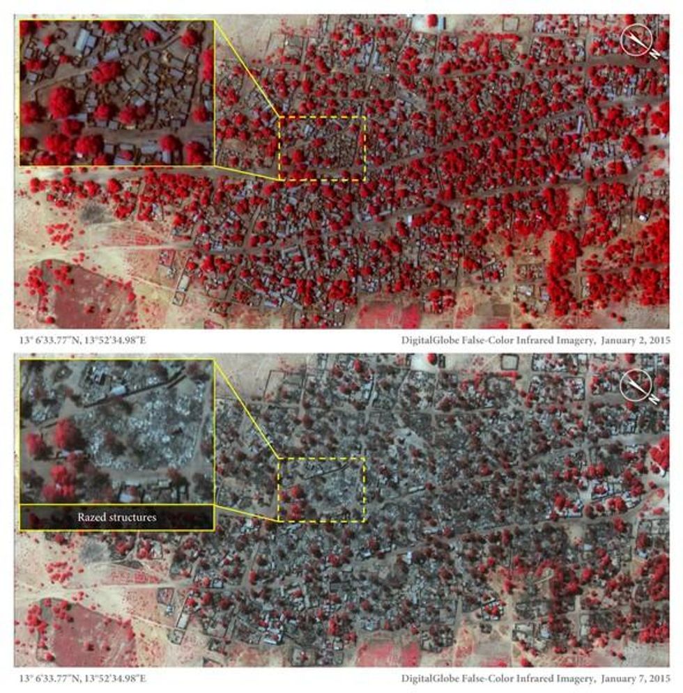
Newly released satellite images have revealed the scope of Boko Haram's January 3 attack on two Nigerian towns, which left hundreds--or possibly thousands--of people dead and thousands more homes burnt to the ground.
Amnesty International released the photographs on Thursday, comparing before-and-after images of the towns of Baga and neighboring Doron Baga, taken on January 2 and January 7, which show more than 3,700 structures damaged or destroyed after what the organization said was the militant group's deadliest attack to date.
"These detailed images show devastation of catastrophic proportions in two towns, one of which was almost wiped off the map in the space of four days," said Amnesty International Nigeria researcher Daniel Eyre. "Of all Boko Haram assaults analyzed by Amnesty International, this is the largest and most destructive yet. It represents a deliberate attack on civilians whose homes, clinics and schools are now burnt out ruins."
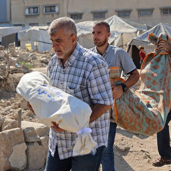
Those who were not killed in the attack on the communities reportedly escaped into nearby woods and across Lake Chad. Survivors later recalled hearing "ceaseless gunshots [and] explosions" and stepping over dead bodies of men, women, and children. Estimates of those killed have varied from 200 to 2,000.
In addition to those dead, the attack left thousands displaced. One survivor told Amnesty, "They killed so many people. I saw maybe around 100 killed at that time in Baga. I ran to the bush. As we were running, they were shooting and killing."
"I don't know how many but there were bodies everywhere we looked," another said.
Witnesses also described that Boko Haram managed to capture many of the women and children who had escaped. After four days, the children and elderly were let go, but the younger women are still being held in school buildings, a survivor said, according to the organization.
Boko Haram reportedly targets certain villages for their perceived cooperation with security forces, particularly state-sponsored militia like the Civilian Joint Task Force, Amnesty explains. CJTF groups were active in Baga.
The satellite images are crucial to assessing the damage in those villages, Eyre said. "Up until now, the isolation of Baga combined with the fact that Boko Haram remains in control of the area has meant that it has been very difficult to verify what happened there," he explained. "Residents have not been able to return to bury the dead, let alone count their number. But through these satellite images combined with graphic testimonies a picture of what is likely to be Boko Haram's deadliest attack ever is becoming clearer."
"This week, Nigeria's Director of Defence Information stated that the number of people killed in Baga including Boko Haram fighters 'has so far not exceeded about 150'," Eyre added. "These images, together with the stories of those who survived the attack, suggest that the final death toll could be much higher than this figure."
Newly released satellite images have revealed the scope of Boko Haram's January 3 attack on two Nigerian towns, which left hundreds--or possibly thousands--of people dead and thousands more homes burnt to the ground.
Amnesty International released the photographs on Thursday, comparing before-and-after images of the towns of Baga and neighboring Doron Baga, taken on January 2 and January 7, which show more than 3,700 structures damaged or destroyed after what the organization said was the militant group's deadliest attack to date.
"These detailed images show devastation of catastrophic proportions in two towns, one of which was almost wiped off the map in the space of four days," said Amnesty International Nigeria researcher Daniel Eyre. "Of all Boko Haram assaults analyzed by Amnesty International, this is the largest and most destructive yet. It represents a deliberate attack on civilians whose homes, clinics and schools are now burnt out ruins."
Those who were not killed in the attack on the communities reportedly escaped into nearby woods and across Lake Chad. Survivors later recalled hearing "ceaseless gunshots [and] explosions" and stepping over dead bodies of men, women, and children. Estimates of those killed have varied from 200 to 2,000.
In addition to those dead, the attack left thousands displaced. One survivor told Amnesty, "They killed so many people. I saw maybe around 100 killed at that time in Baga. I ran to the bush. As we were running, they were shooting and killing."
"I don't know how many but there were bodies everywhere we looked," another said.
Witnesses also described that Boko Haram managed to capture many of the women and children who had escaped. After four days, the children and elderly were let go, but the younger women are still being held in school buildings, a survivor said, according to the organization.
Boko Haram reportedly targets certain villages for their perceived cooperation with security forces, particularly state-sponsored militia like the Civilian Joint Task Force, Amnesty explains. CJTF groups were active in Baga.
The satellite images are crucial to assessing the damage in those villages, Eyre said. "Up until now, the isolation of Baga combined with the fact that Boko Haram remains in control of the area has meant that it has been very difficult to verify what happened there," he explained. "Residents have not been able to return to bury the dead, let alone count their number. But through these satellite images combined with graphic testimonies a picture of what is likely to be Boko Haram's deadliest attack ever is becoming clearer."
"This week, Nigeria's Director of Defence Information stated that the number of people killed in Baga including Boko Haram fighters 'has so far not exceeded about 150'," Eyre added. "These images, together with the stories of those who survived the attack, suggest that the final death toll could be much higher than this figure."