

SUBSCRIBE TO OUR FREE NEWSLETTER
Daily news & progressive opinion—funded by the people, not the corporations—delivered straight to your inbox.
5
#000000
#FFFFFF
To donate by check, phone, or other method, see our More Ways to Give page.
What meteorologists are characterizing as the likely "strongest storm of the year," Super Typhoon Hagupit on Thursday had picked up in both speed and intensity as worries mounted that it could ultimately make landfall later this week on some the same vulnerable Philippines islands that were devastated just over one year ago by Typhoon Haiyan.
As Mashable's Andrew Freeman reports on Thursday:
Super Typhoon Hagupit poses a major, life-threatening danger to the Philippines -- including the same areas of Leyte and eastern Samar that were devastated by Super Typhoon Haiyan last year, and where nearly 100,000 families are still living in highly vulnerable makeshift shelters.
Making matters worse, residents of the central and northern parts of the archipelago are facing considerable forecast uncertainty, with the U.S. Joint Typhoon Warning Center predicting a slow, drenching crossing of northern areas, including a direct hit on the capital of Manila over the weekend.
As those possibly in the storm's path are moving as fast as possible to make preparations, Accuweather reported the storm had sustained winds over 255 kph (160 mph) on Thursday, making it equivalent to a Category 5 hurricane. According to their analysis:
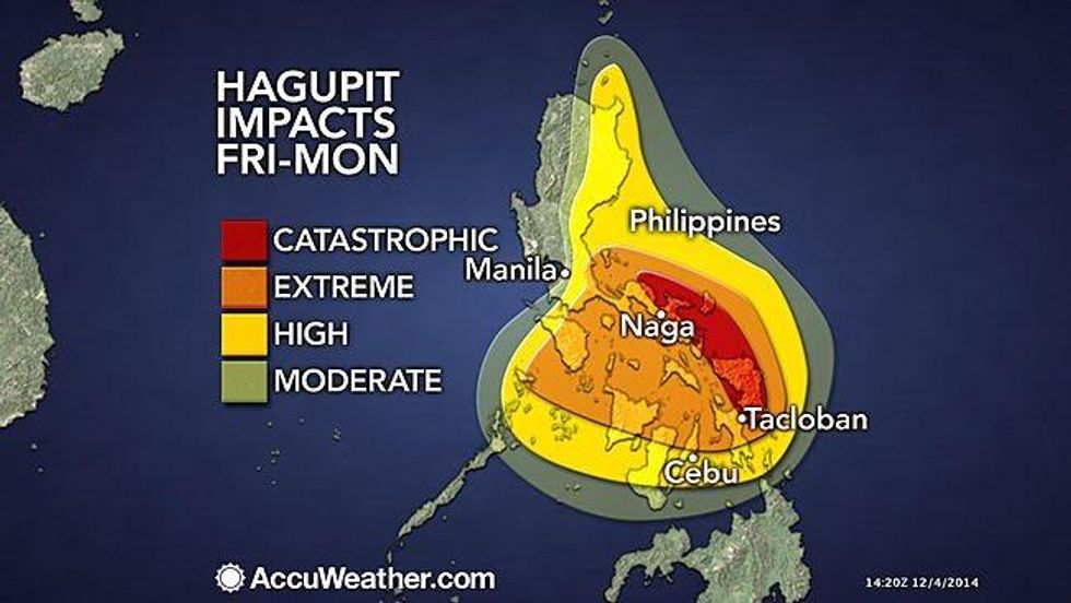
Wind gusts over 240 kph (150 mph) are expected near landfall in eastern Visayas. Landfall is expected within 100 miles of where Super Typhoon Haiyan made landfall last year.
With landfall farther north, the hardest-hit areas by Haiyan will escape the worst tidal surge from Hagupit but will still be severely impacted including the city of Tacloban which was devastated by Haiyan. To make matters worse, some areas are still trying to recover from Haiyan, which will leave them more vulnerable to the impacts of Hagupit.
Meteorologist Jeff Masters, writing at his blog on the Weather Underground website, said that though an extremely large and dangerous storm, certain factors make it less threatening and hopefully less damaging than Haiyan. "There is less heat energy available in the ocean for Hagupit," explained Masters, "and wind shear is expected to rise to the high range on Friday as strong upper-level winds tear at the storm. Heavy rains, not high winds and storm storm surge, will likely be the greatest threat for the Philippines from Hagupit."
In 2013, Super Typhoon Haiyan--one of the most powerful storms ever recorded--devastated the communities in and around the Tacloban region. According to Oxfam International, that storm left more than 6,000 people dead and 4.1 million displaced. As has been noted by climate justice and human rights advocates in the wake Haiyan, the increasing number and intensity of such storms have been widely attributed to the effects of global warming. Experts warn that if global emissions continue to rise, larger, more frequent, and more destructive storms can be expected in the years ahead with low-lying and coastal communities particularly vulnerable.
On Twitter:
What meteorologists are characterizing as the likely "strongest storm of the year," Super Typhoon Hagupit on Thursday had picked up in both speed and intensity as worries mounted that it could ultimately make landfall later this week on some the same vulnerable Philippines islands that were devastated just over one year ago by Typhoon Haiyan.
As Mashable's Andrew Freeman reports on Thursday:
Super Typhoon Hagupit poses a major, life-threatening danger to the Philippines -- including the same areas of Leyte and eastern Samar that were devastated by Super Typhoon Haiyan last year, and where nearly 100,000 families are still living in highly vulnerable makeshift shelters.
Making matters worse, residents of the central and northern parts of the archipelago are facing considerable forecast uncertainty, with the U.S. Joint Typhoon Warning Center predicting a slow, drenching crossing of northern areas, including a direct hit on the capital of Manila over the weekend.
As those possibly in the storm's path are moving as fast as possible to make preparations, Accuweather reported the storm had sustained winds over 255 kph (160 mph) on Thursday, making it equivalent to a Category 5 hurricane. According to their analysis:
Wind gusts over 240 kph (150 mph) are expected near landfall in eastern Visayas. Landfall is expected within 100 miles of where Super Typhoon Haiyan made landfall last year.
With landfall farther north, the hardest-hit areas by Haiyan will escape the worst tidal surge from Hagupit but will still be severely impacted including the city of Tacloban which was devastated by Haiyan. To make matters worse, some areas are still trying to recover from Haiyan, which will leave them more vulnerable to the impacts of Hagupit.
Meteorologist Jeff Masters, writing at his blog on the Weather Underground website, said that though an extremely large and dangerous storm, certain factors make it less threatening and hopefully less damaging than Haiyan. "There is less heat energy available in the ocean for Hagupit," explained Masters, "and wind shear is expected to rise to the high range on Friday as strong upper-level winds tear at the storm. Heavy rains, not high winds and storm storm surge, will likely be the greatest threat for the Philippines from Hagupit."
In 2013, Super Typhoon Haiyan--one of the most powerful storms ever recorded--devastated the communities in and around the Tacloban region. According to Oxfam International, that storm left more than 6,000 people dead and 4.1 million displaced. As has been noted by climate justice and human rights advocates in the wake Haiyan, the increasing number and intensity of such storms have been widely attributed to the effects of global warming. Experts warn that if global emissions continue to rise, larger, more frequent, and more destructive storms can be expected in the years ahead with low-lying and coastal communities particularly vulnerable.
On Twitter:
What meteorologists are characterizing as the likely "strongest storm of the year," Super Typhoon Hagupit on Thursday had picked up in both speed and intensity as worries mounted that it could ultimately make landfall later this week on some the same vulnerable Philippines islands that were devastated just over one year ago by Typhoon Haiyan.
As Mashable's Andrew Freeman reports on Thursday:
Super Typhoon Hagupit poses a major, life-threatening danger to the Philippines -- including the same areas of Leyte and eastern Samar that were devastated by Super Typhoon Haiyan last year, and where nearly 100,000 families are still living in highly vulnerable makeshift shelters.
Making matters worse, residents of the central and northern parts of the archipelago are facing considerable forecast uncertainty, with the U.S. Joint Typhoon Warning Center predicting a slow, drenching crossing of northern areas, including a direct hit on the capital of Manila over the weekend.
As those possibly in the storm's path are moving as fast as possible to make preparations, Accuweather reported the storm had sustained winds over 255 kph (160 mph) on Thursday, making it equivalent to a Category 5 hurricane. According to their analysis:
Wind gusts over 240 kph (150 mph) are expected near landfall in eastern Visayas. Landfall is expected within 100 miles of where Super Typhoon Haiyan made landfall last year.
With landfall farther north, the hardest-hit areas by Haiyan will escape the worst tidal surge from Hagupit but will still be severely impacted including the city of Tacloban which was devastated by Haiyan. To make matters worse, some areas are still trying to recover from Haiyan, which will leave them more vulnerable to the impacts of Hagupit.
Meteorologist Jeff Masters, writing at his blog on the Weather Underground website, said that though an extremely large and dangerous storm, certain factors make it less threatening and hopefully less damaging than Haiyan. "There is less heat energy available in the ocean for Hagupit," explained Masters, "and wind shear is expected to rise to the high range on Friday as strong upper-level winds tear at the storm. Heavy rains, not high winds and storm storm surge, will likely be the greatest threat for the Philippines from Hagupit."
In 2013, Super Typhoon Haiyan--one of the most powerful storms ever recorded--devastated the communities in and around the Tacloban region. According to Oxfam International, that storm left more than 6,000 people dead and 4.1 million displaced. As has been noted by climate justice and human rights advocates in the wake Haiyan, the increasing number and intensity of such storms have been widely attributed to the effects of global warming. Experts warn that if global emissions continue to rise, larger, more frequent, and more destructive storms can be expected in the years ahead with low-lying and coastal communities particularly vulnerable.
On Twitter: