Japanese Prime Minister Noda's promise "to restore people's trust in nuclear policy and safety regulations" is followed by news that the Japanese government withheld important radiation maps from the public. (photo: Kyodo)
To donate by check, phone, or other method, see our More Ways to Give page.
Japanese Prime Minister Noda's promise "to restore people's trust in nuclear policy and safety regulations" is followed by news that the Japanese government withheld important radiation maps from the public. (photo: Kyodo)
The Japanese government admitted on Monday that it did not use U.S.-provided maps showing the spread of radiation in the days after the Fukushima nuclear disaster to evacuate residents in areas with spiked radiation levels.
The newspaper Asahi Shimbunreports that Tetsuya Yamamoto, deputy director-general for safety examination of Japan's Nuclear and Industrial Safety Agency (NISA), told reporters today that the U.S. provided detailed radiation maps taken by the U.S. Energy Department using U.S. military planes on three occasions in the week after the Fukushima disaster began on March 11.
The information, showing residents in an area northwest of the Fukushima Daichi nuclear plant were being exposed to their annual permissible dose of radiation within only eight hours, was not made public, and those residents were not evacuated.
Industry Minister Yukio Edano told reporters today, "It is extremely regrettable that this information was not shared or utilized properly within the government and I have no words to apologize, especially to the disaster victims."
The news of the radiation map blackout comes days after Japan announced it would restart two reactors at the Oi nuclear power plant despite the majority of Japanese people being strongly against nuclear power.
Prime Minister Yoshihiko Noda said of the restart, "We are determined to make further efforts to restore people's trust in nuclear policy and safety regulations."
* * *
Agence France-Presse: Japan sorry for not using US radiation map
Tokyo - A Japanese minister apologized on Tuesday for the nation's failure to make use of a United States-made map showing how radiation was spreading from crippled reactors in the days after the Fukushima crisis.
Tokyo admitted that confusion among government departments meant the map was never used and evacuees were not directed away from areas where radiation from the leaking nuclear plant was spiking.
* * *
Kyodo News: Japan sat on U.S. radiation maps showing immediate fallout from nuke crisis
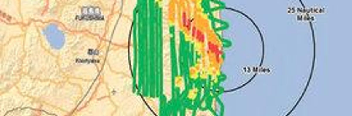
From March 17 to 19, U.S. military aircraft collected radiation data in an area with a 45-km radius from the plant for the U.S. Department of Energy. The data showed that more than 125 microsieverts of radiation per hour was leaking as far as about 25 km northwest of the plant, meaning residents in the area were being exposed to their annual permissible dose within just eight hours.
# # #
Common Dreams is powered by optimists who believe in the power of informed and engaged citizens to ignite and enact change to make the world a better place. We're hundreds of thousands strong, but every single supporter makes the difference. Your contribution supports this bold media model—free, independent, and dedicated to reporting the facts every day. Stand with us in the fight for economic equality, social justice, human rights, and a more sustainable future. As a people-powered nonprofit news outlet, we cover the issues the corporate media never will. Join with us today! |
The Japanese government admitted on Monday that it did not use U.S.-provided maps showing the spread of radiation in the days after the Fukushima nuclear disaster to evacuate residents in areas with spiked radiation levels.
The newspaper Asahi Shimbunreports that Tetsuya Yamamoto, deputy director-general for safety examination of Japan's Nuclear and Industrial Safety Agency (NISA), told reporters today that the U.S. provided detailed radiation maps taken by the U.S. Energy Department using U.S. military planes on three occasions in the week after the Fukushima disaster began on March 11.
The information, showing residents in an area northwest of the Fukushima Daichi nuclear plant were being exposed to their annual permissible dose of radiation within only eight hours, was not made public, and those residents were not evacuated.
Industry Minister Yukio Edano told reporters today, "It is extremely regrettable that this information was not shared or utilized properly within the government and I have no words to apologize, especially to the disaster victims."
The news of the radiation map blackout comes days after Japan announced it would restart two reactors at the Oi nuclear power plant despite the majority of Japanese people being strongly against nuclear power.
Prime Minister Yoshihiko Noda said of the restart, "We are determined to make further efforts to restore people's trust in nuclear policy and safety regulations."
* * *
Agence France-Presse: Japan sorry for not using US radiation map
Tokyo - A Japanese minister apologized on Tuesday for the nation's failure to make use of a United States-made map showing how radiation was spreading from crippled reactors in the days after the Fukushima crisis.
Tokyo admitted that confusion among government departments meant the map was never used and evacuees were not directed away from areas where radiation from the leaking nuclear plant was spiking.
* * *
Kyodo News: Japan sat on U.S. radiation maps showing immediate fallout from nuke crisis
From March 17 to 19, U.S. military aircraft collected radiation data in an area with a 45-km radius from the plant for the U.S. Department of Energy. The data showed that more than 125 microsieverts of radiation per hour was leaking as far as about 25 km northwest of the plant, meaning residents in the area were being exposed to their annual permissible dose within just eight hours.
# # #